IMAGES TAKEN NEAR TO
Church Road, BRISTOL, BS13 8JY
Introduction
This page details the photographs taken nearby to Church Road, BS13 8JY by members of the Geograph project.
The Geograph project started in 2005 with the aim of publishing, organising and preserving representative images for every square kilometre of Great Britain, Ireland and the Isle of Man.

There are currently over 7.5m images from over14,400 individuals and you can help contribute to the project by visiting https://www.geograph.org.uk
Image Map (32 Images)


Getting Data...Please wait
Leaflet Map data © OpenStreetMap
Images are licensed for reuse under creativecommons.org/licenses/by-sa/2.0
Notes
- Clicking on the map will re-center to the selected point.
- The higher the marker number, the further away the image location is from the centre of the postcode.
Image Listing (32 Images Found)
Images are licensed for reuse under creativecommons.org/licenses/by-sa/2.0
Image
Details
Distance
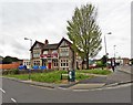
1
United, Reformed but closed
The old UR church in Church Road, now no longer holding services. Following a decline in attendance the Taunton head office decided it was no longer viable and it held a final gathering at the end of 2012.
Originally designed by Mr W. J. Kew, the then Congregational Church Secretary and a local builder who constructed many houses in the Bedminster Down and Uplands area, it opened in 1930. However, it now has an undecided future. Local efforts are being made to keep it but it currently does not have Listed status. Perhaps there may be some hope in the form of achieving a Heritage Asset status, and some control over any changes.
See ChurchCrawler's image of 2005 for comparison - Image
Image: © Neil Owen
Taken: 4 Feb 2013
0.02 miles
2
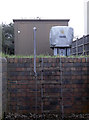
Under wraps
A small electricity installation in Church Road, looking something between a petrol pump and a swimming pool?
Image: © Neil Owen
Taken: 4 Feb 2013
0.03 miles
3
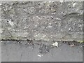
Ordnance Survey Cut Mark
This OS cut mark can be found on the wall east side of Church Road. It marks a point 51.895m above mean sea level.
Image: © Adrian Dust
Taken: 28 Sep 2023
0.04 miles
4
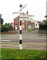
Signpost, Bishopsworth
An old signpost at the junction of Church Road and Grange Road.
Image: © Derek Harper
Taken: 16 Nov 2013
0.04 miles
5
Bishopsworth, Bristol, United Reformed Church
Image: © ChurchCrawler
Taken: 15 May 2005
0.04 miles
6
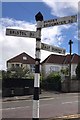
Old Direction Sign - Signpost in Bishopsworth, Bristol parish
Pyramid finial - 4 arms; Somerset SCC pyramid by the UC road, in parish of Bristol (City of Bristol District), Bishopsworth; junction of Church Road with Grange Road.
To be surveyed
Milestone Society National ID: SO_ST5768
Image: © Milestone Society
Taken: Unknown
0.04 miles
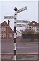
7
Direction Sign ? Signpost
Located on the south side of the Y junction of Church Road and Grange Road in Bishopsworth, Bristol. 4 arms, 1 missing, and pyramid finial. For an older photo see https://www.geograph.org.uk/photo/6049110.
Milestone Society National ID: SO_ST5768
Image: © S Kosciow
Taken: 26 Apr 2019
0.04 miles
8
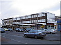
Church Road shops
Parking is a little tight here.
Image: © Neil Owen
Taken: 4 Feb 2013
0.04 miles
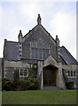
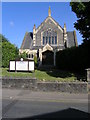
9
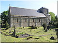
Bishopsworth, Bristol, St Peter's Church
Image: © ChurchCrawler
Taken: 15 May 2005
0.08 miles