IMAGES TAKEN NEAR TO
Cater Road, BRISTOL, BS13 7UH
Introduction
This page details the photographs taken nearby to Cater Road, BS13 7UH by members of the Geograph project.
The Geograph project started in 2005 with the aim of publishing, organising and preserving representative images for every square kilometre of Great Britain, Ireland and the Isle of Man.

There are currently over 7.5m images from over14,400 individuals and you can help contribute to the project by visiting https://www.geograph.org.uk
Image Map (Loading...)


Getting Data...Please wait
Leaflet Map data © OpenStreetMap
Images are licensed for reuse under creativecommons.org/licenses/by-sa/2.0
Notes
- Clicking on the map will re-center to the selected point.
- The higher the marker number, the further away the image location is from the centre of the postcode.
Image Listing (23 Images Found)
Images are licensed for reuse under creativecommons.org/licenses/by-sa/2.0
Image
Details
Distance
2
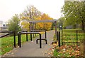
Cycle path near Imperial Park
Obstructions to vehicles on a dual use path north of Hengrove Way, that follows the Pigeonhouse Stream valley through Crox Bottom.
Image: © Derek Harper
Taken: 16 Nov 2013
0.07 miles
4
To Crox Bottom
A footpath from Durville Road
Image: © Neil Owen
Taken: 31 May 2014
0.10 miles
5
Side of The Range, Imperial Retail Park
The south side of The Range, a 60,000 square foot store for home, leisure and garden. Taken from a service road. I was hoping to explore further along it, not being very interested in what any of the stores had to offer, but a notice forbade further public progress, which seems a trifle mean.
Image: © Derek Harper
Taken: 8 Sep 2013
0.11 miles
6
Old Imperial Tobacco Head Quarters
This was called the Podium, and from its basement was a tunnel to the factory which has been pulled down. BBC used the tunnel in early Dr Who shots. It is now being converted into accommodation.
Image: © Rick Crowley
Taken: 27 Nov 2008
0.12 miles
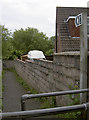
7
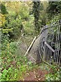
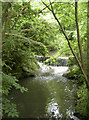
Damaged fence, Pigeonhouse Stream
Just below a large pond and a couple of weirs on the stream.
Image: © Derek Harper
Taken: 16 Nov 2013
0.13 miles
8
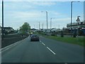
Row of Houses, Whitland Road, Bristol
Row of houses on the far side of the South Bristol Link Road, Whitchurch Lane, viewed from WCP Parking Reception (foreground).
Image: © M J Roscoe
Taken: 24 Nov 2017
0.13 miles
9
Upper weir
Taken from the bridge at the upper reaches of Crox Bottom.
Image: © Neil Owen
Taken: 31 May 2014
0.15 miles
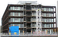
10
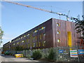
The Copper Building, Lakeshore
Work continues on the latest apartment block.
Image: © Neil Owen
Taken: 30 May 2019
0.15 miles