IMAGES TAKEN NEAR TO
Hill View Road, BRISTOL, BS13 7LE
Introduction
This page details the photographs taken nearby to Hill View Road, BS13 7LE by members of the Geograph project.
The Geograph project started in 2005 with the aim of publishing, organising and preserving representative images for every square kilometre of Great Britain, Ireland and the Isle of Man.

There are currently over 7.5m images from over14,400 individuals and you can help contribute to the project by visiting https://www.geograph.org.uk
Image Map
Images are licensed for reuse under creativecommons.org/licenses/by-sa/2.0
Notes
- Clicking on the map will re-center to the selected point.
- The higher the marker number, the further away the image location is from the centre of the postcode.
Image Listing (35 Images Found)
Images are licensed for reuse under creativecommons.org/licenses/by-sa/2.0
Image
Details
Distance
1
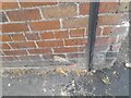
Ordnance Survey Cut Mark
This OS cut mark can be found on No151 Bishopsworth Road. It marked a point 61.786m above mean sea level.
Image: © Adrian Dust
Taken: 5 Aug 2022
0.04 miles
3
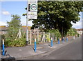
School kit
Cheddar Grove primary school now has some more equipment to keep the roads clear.
Image: © Neil Owen
Taken: 2 Aug 2014
0.12 miles
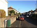
4
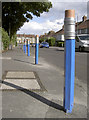
Draw your own conclusions
Cheddar Grove Primary School is (like many) clogged by cars at leaving time as anxious parents wait for their precious offspring. In order to prevent them from sprawling all over the junction here the local council have installed these fetching bollards. Whether it deters them will be seen.
Image: © Neil Owen
Taken: 2 Aug 2014
0.12 miles
5
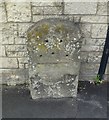
Old Milestone by Bishopsworth Road, Bristol parish
Stone post (plate lost) by the UC road, in parish of BRISTOL (CITY OF BRISTOL District), Bishopsworth Road, Bedminster Down, by No 138, in pavement, back to block wall, on West side of road. Bristol iron plate, erected by the Bristol turnpike trust in the 19th century.
Inscription once read:-
(BRISTOL 2)
(CHEW STOKE 5)
Carved benchmark top right.
Milestone Society National ID: SO_BRWL02.
Image: © M Faherty
Taken: 21 Jul 2011
0.13 miles
6
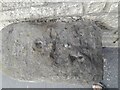
Ordnance Survey Rivet
This OS rivet can be found on the milestone west side of Bishopsworth Road. It marks a point 51.338m above mean sea level.
Image: © Adrian Dust
Taken: 5 Aug 2022
0.14 miles
7
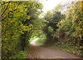
Path, Manor Woods Valley
Footpath BCC/501 drops past trees to run closer to The Malago.
Image: © Derek Harper
Taken: 16 Nov 2013
0.14 miles
8
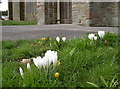
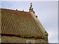
Greeting the parishioners
Some crocuses in front of St Oswald's.
Image: © Neil Owen
Taken: 4 Mar 2014
0.16 miles
9
Order of service
St Oswald's church congregation, with the gulls at the head of the procession.
Image: © Neil Owen
Taken: 4 Mar 2014
0.16 miles
10
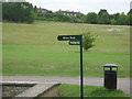
Woodland or River? It's Your Choice
The walkers in Manor Woods Valley are here offered a choice.
Image: © Dr Duncan Pepper
Taken: 18 Jun 2009
0.16 miles