IMAGES TAKEN NEAR TO
St. Stephens Avenue, BRISTOL, BS1 1YL
Introduction
This page details the photographs taken nearby to St. Stephens Avenue, BS1 1YL by members of the Geograph project.
The Geograph project started in 2005 with the aim of publishing, organising and preserving representative images for every square kilometre of Great Britain, Ireland and the Isle of Man.

There are currently over 7.5m images from over14,400 individuals and you can help contribute to the project by visiting https://www.geograph.org.uk
Image Map
Images are licensed for reuse under creativecommons.org/licenses/by-sa/2.0
Notes
- Clicking on the map will re-center to the selected point.
- The higher the marker number, the further away the image location is from the centre of the postcode.
Image Listing (1946 Images Found)
Images are licensed for reuse under creativecommons.org/licenses/by-sa/2.0
Image
Details
Distance
1
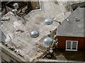
View from St Stephen's (6)
Three skylights on the roof of an office block close to St Stephen's - a case of eyes on the sky?
Image: © Neil Owen
Taken: 14 Sep 2013
0.01 miles
2
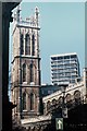
Architecture Ancient and Modern
Fifteenth century St Stephen's Church in perpendicular gothic and a modernist Twentieth Century office block make interesting neighbours in central Bristol.
Image: © John H Darch
Taken: Unknown
0.01 miles
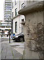
3
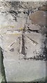
Ordnance Survey Cut Mark
This OS cut mark can be found on the SW angle of St Stephen's Church. It marks a point 9.7506m above mean sea level.
Image: © Adrian Dust
Taken: 29 Feb 2016
0.01 miles
4
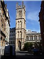
Bristol's beautiful buildings [15]
The tower of the church of St Stephen has some unusual open square turrets at the top. The church is listed, grade I, with details at: https://www.historicengland.org.uk/listing/the-list/list-entry/1202558
Image: © Michael Dibb
Taken: 13 Aug 2016
0.01 miles
5
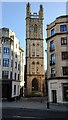
Tower of St Stephen's Church
The always impressive Grade 1 Listed Saint Stephen’s tower was built in 1470 by John Shipward (d.1473), four times Mayor of Bristol, the same year the church itself was rebuilt.
Image: © Marvin653
Taken: 25 Nov 2021
0.01 miles
6
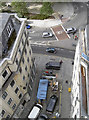
View from St Stephen's (14)
Looking down from the tower to the end of St Stephen's Avenue, where some building work has necessitated the use of skips.
Image: © Neil Owen
Taken: 14 Sep 2013
0.01 miles
7
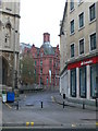
Clare Street, Bristol
A glimpse up Clare Street, towards an imposing terracotta building which was built for the Prudential Assurance at the end of the 19th century.
Image: © Eirian Evans
Taken: 20 Nov 2010
0.01 miles
8
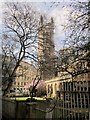
St Stephen's church, Bristol
Footpath BCC/324/10 cuts alongside the tiny but charming churchyard of St Stephen's http://list.english-heritage.org.uk/resultsingle.aspx?uid=1202558&searchtype=mapsearch . The mid-C19 walls, gates and railings are listed http://list.english-heritage.org.uk/resultsingle.aspx?uid=1279619&searchtype=mapsearch .
Image: © Derek Harper
Taken: 15 Mar 2014
0.01 miles
9
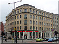
6-12 Colston Avenue, Bristol
Shops and offices, probably early 1950s.
Santander bank had the corner of St Stephen's Avenue.
Image: © Stephen Richards
Taken: 20 May 2012
0.01 miles
10
Benchmark on the tower
A cut benchmark placed on the tower of St Stephen's church, on St Stephen's Avenue; it's clearly had to contend with a fair amount of city centre conditions but can still be useful as the yellow marking may indicate. See Image] for a taller view and http://www.bench-marks.org.uk/bm28918 for the Benchmark Database.
Image: © Neil Owen
Taken: 26 Jul 2011
0.01 miles