IMAGES TAKEN NEAR TO
Myrtle Drive, BRISTOL, BS11 9XX
Introduction
This page details the photographs taken nearby to Myrtle Drive, BS11 9XX by members of the Geograph project.
The Geograph project started in 2005 with the aim of publishing, organising and preserving representative images for every square kilometre of Great Britain, Ireland and the Isle of Man.

There are currently over 7.5m images from over14,400 individuals and you can help contribute to the project by visiting https://www.geograph.org.uk
Image Map
Images are licensed for reuse under creativecommons.org/licenses/by-sa/2.0
Notes
- Clicking on the map will re-center to the selected point.
- The higher the marker number, the further away the image location is from the centre of the postcode.
Image Listing (26 Images Found)
Images are licensed for reuse under creativecommons.org/licenses/by-sa/2.0
Image
Details
Distance
2
A view east from Shirehampton railway station, Bristol
Looking towards the Hung Road bridge. The station http://www.geograph.org.uk/photo/3290321 is on the Severn Beach line.
Image: © Jaggery
Taken: 23 Jun 2012
0.15 miles
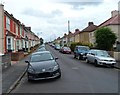
3
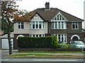
Shirehampton : Houses
Houses along the A4 Portway Road.
Image: © Lewis Clarke
Taken: 30 May 2015
0.17 miles
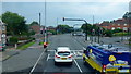
4

Woodwell Road, Shirehampton
Junction with the A4 Portway, seen from the bus on the north side of the carriageway.
Image: © Jonathan Billinger
Taken: 2 May 2015
0.18 miles
5
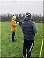
At the sidelines
Parents concentrating on a junior football match
Image: © Eirian Evans
Taken: 23 Jan 2022
0.18 miles
6
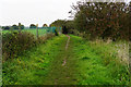
Footpath near the River Avon
The river is a few yards to the right. On the other side of the fence to the left is a sports and social club.
Image: © Bill Boaden
Taken: 27 Sep 2017
0.19 miles
7
A4 Portway at Shirehampton
The Hung Road crossroads.
'Hung' refers to the practice of tying up vessels by the tidal Avon to keep them upright when the tide was low.
Image: © Jonathan Billinger
Taken: 13 Sep 2016
0.19 miles
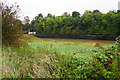
8
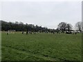
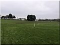
Junior Sunday Football game at Port of Bristol Playing Field
Image: © Eirian Evans
Taken: 23 Jan 2022
0.20 miles
9
Western end of Dursley Road, Shirehampton, Bristol
In this part of Dursley Road, between Station Road and the Coaley Road junction (ahead), a long row of houses on the north side of the road faces semi-detached houses on the south side.
Image: © Jaggery
Taken: 23 Jun 2012
0.20 miles
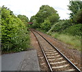
10
The River Avon near Shirehampton
Viewed from the Severn Way path.
Image: © Bill Boaden
Taken: 27 Sep 2017
0.21 miles