IMAGES TAKEN NEAR TO
Dursley Road, BRISTOL, BS11 9XQ
Introduction
This page details the photographs taken nearby to Dursley Road, BS11 9XQ by members of the Geograph project.
The Geograph project started in 2005 with the aim of publishing, organising and preserving representative images for every square kilometre of Great Britain, Ireland and the Isle of Man.

There are currently over 7.5m images from over14,400 individuals and you can help contribute to the project by visiting https://www.geograph.org.uk
Image Map (Loading...)


Getting Data...Please wait
Leaflet Map data © OpenStreetMap
Images are licensed for reuse under creativecommons.org/licenses/by-sa/2.0
Notes
- Clicking on the map will re-center to the selected point.
- The higher the marker number, the further away the image location is from the centre of the postcode.
Image Listing (35 Images Found)
Images are licensed for reuse under creativecommons.org/licenses/by-sa/2.0
Image
Details
Distance
1

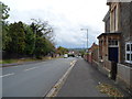
Woodwell Road, Shirehampton
Junction with the A4 Portway, seen from the bus on the north side of the carriageway.
Image: © Jonathan Billinger
Taken: 2 May 2015
0.08 miles
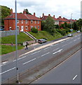
2
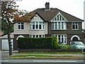
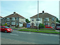
Shirehampton : Houses
Houses along the A4 Portway Road.
Image: © Lewis Clarke
Taken: 30 May 2015
0.12 miles
4
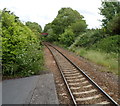
A view east from Shirehampton railway station, Bristol
Looking towards the Hung Road bridge. The station http://www.geograph.org.uk/photo/3290321 is on the Severn Beach line.
Image: © Jaggery
Taken: 23 Jun 2012
0.15 miles
5
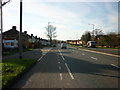
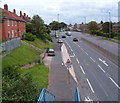
A4 Portway at Shirehampton
The Hung Road crossroads.
'Hung' refers to the practice of tying up vessels by the tidal Avon to keep them upright when the tide was low.
Image: © Jonathan Billinger
Taken: 13 Sep 2016
0.16 miles
6
Hung Road, Shirehampton, Bristol
Viewed from Station Road looking towards The Portway (the A4). The unusually named road was formerly named Hung Road Lane, which led to the part of the River Avon known as Hung Road.
Image: © Jaggery
Taken: 23 Jun 2012
0.17 miles
7
Shirehampton : Houses on Portway Road
Houses alongside Portway Road A4.
Image: © Lewis Clarke
Taken: 30 May 2015
0.18 miles
8
The Portway east of a footbridge, Shirehampton, Bristol
The Portway (the A4) viewed from this footbridge. http://www.geograph.org.uk/photo/3281129
Image: © Jaggery
Taken: 23 Jun 2012
0.19 miles
9
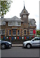
Clock tower, Shirehampton Library, Bristol
Viewed across Station Road. The library occupies part of the Public Hall. http://www.geograph.org.uk/photo/3281094
Image: © Jaggery
Taken: 23 Jun 2012
0.19 miles
10
The Portway houses, Shirehampton, Bristol
Viewed from this http://www.geograph.org.uk/photo/3281129 footbridge. The Portway is part of the A4 road.
Image: © Jaggery
Taken: 23 Jun 2012
0.19 miles