IMAGES TAKEN NEAR TO
Springfield Avenue, BRISTOL, BS11 9TQ
Introduction
This page details the photographs taken nearby to Springfield Avenue, BS11 9TQ by members of the Geograph project.
The Geograph project started in 2005 with the aim of publishing, organising and preserving representative images for every square kilometre of Great Britain, Ireland and the Isle of Man.

There are currently over 7.5m images from over14,400 individuals and you can help contribute to the project by visiting https://www.geograph.org.uk
Image Map
Images are licensed for reuse under creativecommons.org/licenses/by-sa/2.0
Notes
- Clicking on the map will re-center to the selected point.
- The higher the marker number, the further away the image location is from the centre of the postcode.
Image Listing (32 Images Found)
Images are licensed for reuse under creativecommons.org/licenses/by-sa/2.0
Image
Details
Distance
3
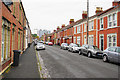
Priory Road
A long terraced street in Shirehampton. On the opposite side on No. 34 is a blue plaque showing where Sir Robert Stephens, actor, lived between 1931 and 1939.
Image: © Bill Boaden
Taken: 27 Sep 2017
0.13 miles
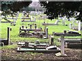
4
Shirehampton Cemetery
A view in the direction of the Avon in rain.
Image: © Bill Boaden
Taken: 27 Sep 2017
0.14 miles
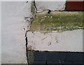
5
Ordnance Survey Cut Mark
This OS cut mark can be found on No59 Walton Road. It marks a point 30.020m above mean sea level.
Image: © Adrian Dust
Taken: 12 Mar 2020
0.14 miles
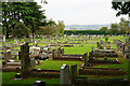
6
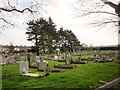
Shirehampton Cemetery
The cemetery was opened in 1898. this view is from its northern corner at the junction of St Mary's Road and St Mary's Walk.
Image: © Derek Harper
Taken: 29 Mar 2014
0.15 miles
7
Ordnance Survey Cut Mark
This OS cut mark can be found on No1 Severn Road. It marks a point 32.434m above mean sea level.
Image: © Adrian Dust
Taken: 12 Mar 2020
0.17 miles
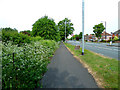
8
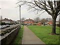
St Mary's Road, Shirehampton
With a grassy area beside Jim O'Neil House on the right. The junction ahead on the right is with Beachley Walk.
Image: © Derek Harper
Taken: 29 Mar 2014
0.18 miles
9
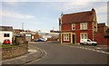
Junction, Shirehampton
Seen from St Mary's Road. Round the corner ahead is Pembroke Road; to the right is Priory Road. The low building left of centre is a Co-op supermarket.
Image: © Derek Harper
Taken: 29 Mar 2014
0.19 miles
10
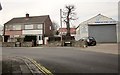
Houses and garage, Shirehampton
The garage can be seen on the extreme left of Image The road bends left to reach the junction shown there.
Image: © Derek Harper
Taken: 29 Mar 2014
0.19 miles