IMAGES TAKEN NEAR TO
Burnham Road, BRISTOL, BS11 9QP
Introduction
This page details the photographs taken nearby to Burnham Road, BS11 9QP by members of the Geograph project.
The Geograph project started in 2005 with the aim of publishing, organising and preserving representative images for every square kilometre of Great Britain, Ireland and the Isle of Man.

There are currently over 7.5m images from over14,400 individuals and you can help contribute to the project by visiting https://www.geograph.org.uk
Image Map
Images are licensed for reuse under creativecommons.org/licenses/by-sa/2.0
Notes
- Clicking on the map will re-center to the selected point.
- The higher the marker number, the further away the image location is from the centre of the postcode.
Image Listing (80 Images Found)
Images are licensed for reuse under creativecommons.org/licenses/by-sa/2.0
Image
Details
Distance
1
Ordnance Survey Cut Mark
This OS cut mark can be found on No59 Walton Road. It marks a point 30.020m above mean sea level.
Image: © Adrian Dust
Taken: 12 Mar 2020
0.07 miles
2
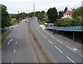
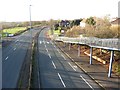
The Portway west of a footbridge, Shirehampton, Bristol
The Portway (the A4) viewed from this footbridge. http://www.geograph.org.uk/photo/3281129
Image: © Jaggery
Taken: 23 Jun 2012
0.11 miles
3
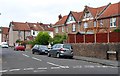
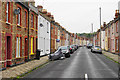
Springfield Avenue, Shirehampton, Bristol
Viewed from the corner of Station Road and Hung Road.
Image: © Jaggery
Taken: 23 Jun 2012
0.12 miles
4
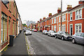
Priory Road
A long terraced street in Shirehampton. On the opposite side on No. 34 is a blue plaque showing where Sir Robert Stephens, actor, lived between 1931 and 1939.
Image: © Bill Boaden
Taken: 27 Sep 2017
0.12 miles
5
Track through The Daisy Field, Lamplighters Marsh, Shirehampton, Bristol
Viewed from the edge of Station Road, where an information board states that The Daisy Field is managed by Bristol Parks working with Shirehampton Community Action Forum.
Image: © Jaggery
Taken: 23 Jun 2012
0.12 miles
6
Bradley Crescent
A terraced street in Shirehampton with differing styles along the street.
Image: © Bill Boaden
Taken: 27 Sep 2017
0.12 miles
7
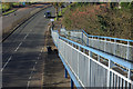
Portway, Shirehampton
Looking down from the footbridge which connects the two sections of Station Road for pedestrians, this is the A4 in the last couple of miles or so before it ends at Avonmouth.
Image: © Stephen McKay
Taken: 10 Nov 2010
0.13 miles
8
Shirehampton : Portway Bus Stop
A bus stop on the Portway Road.
Image: © Lewis Clarke
Taken: 30 May 2015
0.13 miles
10
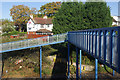
Footbridge over Portway
Looking across this footbridge over the A4 Portway at Shirehampton to a house sporting a flagpole complete with Union flag - a patriotic practice common in the USA, but rare in Britain.
Image: © Stephen McKay
Taken: 10 Nov 2010
0.13 miles