IMAGES TAKEN NEAR TO
Akeman Way, BRISTOL, BS11 9NU
Introduction
This page details the photographs taken nearby to Akeman Way, BS11 9NU by members of the Geograph project.
The Geograph project started in 2005 with the aim of publishing, organising and preserving representative images for every square kilometre of Great Britain, Ireland and the Isle of Man.

There are currently over 7.5m images from over14,400 individuals and you can help contribute to the project by visiting https://www.geograph.org.uk
Image Map
Images are licensed for reuse under creativecommons.org/licenses/by-sa/2.0
Notes
- Clicking on the map will re-center to the selected point.
- The higher the marker number, the further away the image location is from the centre of the postcode.
Image Listing (56 Images Found)
Images are licensed for reuse under creativecommons.org/licenses/by-sa/2.0
Image
Details
Distance
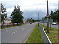
1
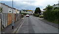
Akeman Way, Avonmouth, Bristol
Viewed from the Avonmouth Road end.
Image: © Jaggery
Taken: 23 Jun 2012
0.02 miles
2
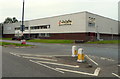
Howdens Joinery, Avonmouth, Bristol
The Howdens depot is at Unit 1, Avonbridge Trading Estate, Atlantic Road, viewed across Avonmouth Road. This is one of about 520 Howdens depots where trade professionals can buy a range of kitchens and joinery products, and accessories, worktops, sinks and taps etc. Howdens do not sell direct to the general public.
Image: © Jaggery
Taken: 23 Jun 2012
0.05 miles
3
An Avonmouth skyline
Avonmouth is particularly associated with the docks, heavy industries and retail parks. It is also home to several thousand people.
Image: © Neil Owen
Taken: 6 Feb 2023
0.06 miles
4
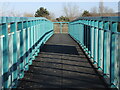
Footbridge over Portway
A modern metal structure over the dual-carriageway. The latter was built in the 1960s (as was the bridge) when the old road was widened to accept the motorway link and roundabout.
Image: © Neil Owen
Taken: 6 Feb 2023
0.06 miles
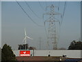
5
Northern end of The Portway, Avonmouth, Bristol
Viewed from the Portway Roundabout, which marks the Avonmouth end of The Portway, a trunk road c10 km long which links the centre of Bristol with its port here at Avonmouth. It is part of the A4 road.
Image: © Jaggery
Taken: 23 Jun 2012
0.06 miles
6
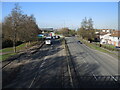
Portway north
A view from the bridge to the roundabout and the motorway link.
Image: © Neil Owen
Taken: 6 Feb 2023
0.06 miles
7
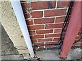
Ordnance Survey Cut Mark
This OS cut mark can be found on No49 Avonmouth Road. It marks a point 7.955m above mean sea level.
Image: © Adrian Dust
Taken: 29 Sep 2023
0.07 miles
8
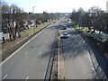
Portway south
Leading down the road, through Avonmouth and on towards the Avon Gorge.
Image: © Neil Owen
Taken: 6 Feb 2023
0.10 miles
9
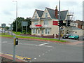
Bradford Hotel
On Avonmouth Road with a fine view of the roundabout at the end of the M5 spur.
Image: © Jonathan Billinger
Taken: 16 Jul 2009
0.13 miles
10
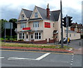
The Bradford Hotel, Avonmouth, Bristol
Located on the corner of Avonmouth Road and Cook Street, opposite the Portway Roundabout.
Image: © Jaggery
Taken: 23 Jun 2012
0.14 miles