IMAGES TAKEN NEAR TO
Long Cross, BRISTOL, BS11 0TG
Introduction
This page details the photographs taken nearby to Long Cross, BS11 0TG by members of the Geograph project.
The Geograph project started in 2005 with the aim of publishing, organising and preserving representative images for every square kilometre of Great Britain, Ireland and the Isle of Man.

There are currently over 7.5m images from over14,400 individuals and you can help contribute to the project by visiting https://www.geograph.org.uk
Image Map
Images are licensed for reuse under creativecommons.org/licenses/by-sa/2.0
Notes
- Clicking on the map will re-center to the selected point.
- The higher the marker number, the further away the image location is from the centre of the postcode.
Image Listing (5 Images Found)
Images are licensed for reuse under creativecommons.org/licenses/by-sa/2.0
Image
Details
Distance
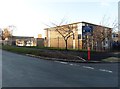
2
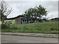
Ambition Lawrence Weston
Lawrence Weston is a post-war housing estate on the north west outskirts of Bristol. Ambition Lawrence Weston was established in 2012 by a group of residents who wanted to make the area a better place to live, after a decline in local services. This blue building is the Lawrence Weston Youth and Community Centre
Image: © Eirian Evans
Taken: 23 Jan 2022
0.16 miles
3
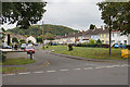
Aylminton Walk
A residential street on the edge of Lawrence Weston.
Image: © Bill Boaden
Taken: 27 Sep 2017
0.21 miles
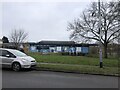
4
Theatre Benedictus
Part of St. Bede's Catholic College
Image: © don cload
Taken: 16 Dec 2017
0.22 miles
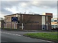
5
St Bede's Catholic College, Lawrence Weston
Image: © Roger Cornfoot
Taken: 9 Dec 2019
0.23 miles