IMAGES TAKEN NEAR TO
Tufton Avenue, BRISTOL, BS11 0LA
Introduction
This page details the photographs taken nearby to Tufton Avenue, BS11 0LA by members of the Geograph project.
The Geograph project started in 2005 with the aim of publishing, organising and preserving representative images for every square kilometre of Great Britain, Ireland and the Isle of Man.

There are currently over 7.5m images from over14,400 individuals and you can help contribute to the project by visiting https://www.geograph.org.uk
Image Map
Images are licensed for reuse under creativecommons.org/licenses/by-sa/2.0
Notes
- Clicking on the map will re-center to the selected point.
- The higher the marker number, the further away the image location is from the centre of the postcode.
Image Listing (47 Images Found)
Images are licensed for reuse under creativecommons.org/licenses/by-sa/2.0
Image
Details
Distance
1
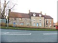
Terraced cottages on Kings Weston Lane
Image: © Roger Cornfoot
Taken: 9 Dec 2019
0.05 miles
2
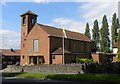
Our Lady of the Rosary Church
A Roman Catholic Church on Kings Weston Lane.
Image: © Colin Bews
Taken: 26 Jul 2011
0.09 miles
3
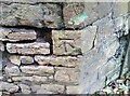
Ordnance Survey Cut Mark
This OS cut mark can be found on the wall SW side of King Weston Lane. It marks a point 49.881m above mean sea level.
Image: © Adrian Dust
Taken: 1 Nov 2021
0.13 miles
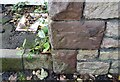
4
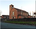
Church of our lady of the rosary, Kings Weston
Image: © Roger Cornfoot
Taken: 9 Dec 2019
0.15 miles
5
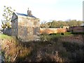
Remains of pond at Kings Weston School
Image: © Roger Cornfoot
Taken: 9 Dec 2019
0.18 miles
6

Moor Grove
A residential road on the lower slopes of Kings Weston Hill.
Image: © Bill Boaden
Taken: 27 Sep 2017
0.18 miles
7
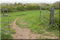
Field near Kingsweston House
Footpath BCC 565/10 carries the Severn Way into this meadow with a view to the Severn estuary.
Image: © Derek Harper
Taken: 18 Apr 2022
0.18 miles
8
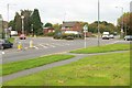
Roundabout, Lawrence Weston
In the very northern corner of the square. On the immediate left is Kings Weston Lane, continuing straight across Long Cross, the main route through Lawrence Weston.
Image: © Derek Harper
Taken: 19 Oct 2016
0.18 miles
9
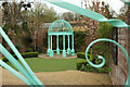
Circular feature, Kings Weston House
In Torquay's Tessier Gardens, a very similar structure is called the "sun temple" Image Perhaps "gazebo", "bower" or "arbour" is more generic. My word for the colour is bold.
Image: © Derek Harper
Taken: 18 Apr 2022
0.19 miles
10
Ordnance Survey Cut Mark
This OS cut mark can be found on the Lodge on King Weston Lane. It marks a point 60.586m above mean sea level.
Image: © Adrian Dust
Taken: 1 Nov 2021
0.19 miles