IMAGES TAKEN NEAR TO
Barrowmead Drive, BRISTOL, BS11 0JR
Introduction
This page details the photographs taken nearby to Barrowmead Drive, BS11 0JR by members of the Geograph project.
The Geograph project started in 2005 with the aim of publishing, organising and preserving representative images for every square kilometre of Great Britain, Ireland and the Isle of Man.

There are currently over 7.5m images from over14,400 individuals and you can help contribute to the project by visiting https://www.geograph.org.uk
Image Map
Images are licensed for reuse under creativecommons.org/licenses/by-sa/2.0
Notes
- Clicking on the map will re-center to the selected point.
- The higher the marker number, the further away the image location is from the centre of the postcode.
Image Listing (32 Images Found)
Images are licensed for reuse under creativecommons.org/licenses/by-sa/2.0
Image
Details
Distance
1
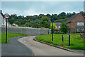
Shirehampton : Long Cross
Looking along Long Cross.
Image: © Lewis Clarke
Taken: 8 Sep 2020
0.11 miles
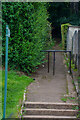
2
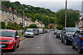
Shirehampton : Mancroft Avenue
A residential road.
Image: © Lewis Clarke
Taken: 8 Sep 2020
0.11 miles
3
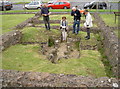
Shirehampton : Long Cross
Part of a minor Romano-British villa can be seen here.
Image: © Lewis Clarke
Taken: 8 Sep 2020
0.12 miles
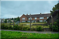
4

Kings Weston Roman villa
The site is surrounded by more modern housing.
Image: © Bill Boaden
Taken: 27 Sep 2017
0.12 miles
5
Kingsweston Roman Villa
The villa is largely replaced by the main road running to the right of shot. Most of the more interesting sections of the villa are believed to have been ripped up by the construction, but the excavations of 1948/9 have left us with the southern half, including the main entrance and portico. See Image] and Image] for more.
Image: © Neil Owen
Taken: 10 Sep 2011
0.12 miles
6
Kingsweston Roman Villa
A better view of the heated room, with its distinctively Roman hypocaust. Taken on Bristol's Open Doors day. See Image] for another view.
Image: © Neil Owen
Taken: 10 Sep 2011
0.12 miles
7
Kingsweston Roman Villa
A view of the building outlines from the East. The small room nearest the camera has a hypocaust (underfloor heating) and the wooden hut to the left shelters mosaics. See Image] and Image] for more.
Image: © Neil Owen
Taken: 10 Sep 2011
0.12 miles
8
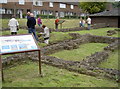
Kings Weston Roman Villa
https://historicengland.org.uk/listing/the-list/list-entry/1006999?section=official-listing
Image: © Sandy Gerrard
Taken: Unknown
0.12 miles
9
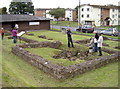
Kings Weston Roman Villa
The footings are the only remaining evidence left of this modest roman building. Most of the extent has unfortunately been lost under the road nearby. See Image] and Image] for more views, inside and out.
Image: © Neil Owen
Taken: 10 Sep 2011
0.12 miles
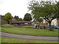
10
Shirehampton : Footpath
A footpath heads into the woods from Mancroft Road.
Image: © Lewis Clarke
Taken: 8 Sep 2020
0.12 miles