IMAGES TAKEN NEAR TO
Grainger Court, The Ridge, BRISTOL, BS11 0BS
Introduction
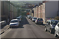
This page details the photographs taken nearby to Grainger Court, The Ridge, BS11 0BS by members of the Geograph project.
The Geograph project started in 2005 with the aim of publishing, organising and preserving representative images for every square kilometre of Great Britain, Ireland and the Isle of Man.

There are currently over 7.5m images from over14,400 individuals and you can help contribute to the project by visiting https://www.geograph.org.uk
Image Map
Images are licensed for reuse under creativecommons.org/licenses/by-sa/2.0
Notes
- Clicking on the map will re-center to the selected point.
- The higher the marker number, the further away the image location is from the centre of the postcode.
Image Listing (107 Images Found)
Images are licensed for reuse under creativecommons.org/licenses/by-sa/2.0
Image
Details
Distance
1
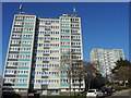
Barwick and Sedgewick - tallest in Shirehampton
Two tower blocks (Barwick to the left) in Shirehampton, built in the latter part of the 1960s. Barwick House has a few Huawei telecommunication masts atop. In the wake of the Grenfell Tower disaster, it emerged that the blocks are clad in some concerning materials but is considered a lower risk due to it fitting directly to the concrete walls.
Image: © Neil Owen
Taken: 6 Feb 2023
0.05 miles
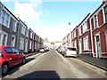
3
Penpole Avenue, Shirehampton, Bristol
Viewed from the High Street end.
Image: © Jaggery
Taken: 23 Jun 2012
0.06 miles
5
Penpole Avenue, Shirehampton
Looking down Penpole Avenue towards Shirehampton High Street with land to the south of the River Avon stretched away in the distance.
Image: © Stephen McKay
Taken: 10 Nov 2010
0.07 miles
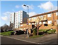
6
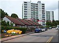
Bungalows and highrise flats, Shirehampton, Bristol
Though now part of Bristol, Shirehampton retains some elements of its former status as a village.
I was surprised on turning the corner from High Street into The Ridge to see these two highrise blocks
of flats, Barwick House and Sedgewick House.
Image: © Jaggery
Taken: 23 Jun 2012
0.07 miles
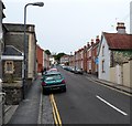
7
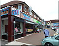
A row of High Street shops, Shirehampton, Bristol
There is a parking area alongside the shops, but of course no guarantee of a place to park. http://www.geograph.org.uk/photo/3298609
Image: © Jaggery
Taken: 23 Jun 2012
0.07 miles
8
A closed shop, a whitened window
A small shop window has been given a wipe over as the proprietor has left for good.
Image: © Neil Owen
Taken: 6 Feb 2023
0.07 miles
9
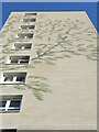
Foliage on Sedgewick House
The side of the high-rise block has seen many coats of paint in the past, with the present decoration a departure from the linear rectangles and bands.
Image: © Neil Owen
Taken: 6 Feb 2023
0.07 miles
10
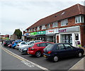
Parking area alongside High Street shops, Shirehampton, Bristol
This view shows one drawback of a conveniently-located free parking area...
Image: © Jaggery
Taken: 23 Jun 2012
0.07 miles