IMAGES TAKEN NEAR TO
Bishopthorpe Road, BRISTOL, BS10 5AE
Introduction
This page details the photographs taken nearby to Bishopthorpe Road, BS10 5AE by members of the Geograph project.
The Geograph project started in 2005 with the aim of publishing, organising and preserving representative images for every square kilometre of Great Britain, Ireland and the Isle of Man.

There are currently over 7.5m images from over14,400 individuals and you can help contribute to the project by visiting https://www.geograph.org.uk
Image Map
Images are licensed for reuse under creativecommons.org/licenses/by-sa/2.0
Notes
- Clicking on the map will re-center to the selected point.
- The higher the marker number, the further away the image location is from the centre of the postcode.
Image Listing (41 Images Found)
Images are licensed for reuse under creativecommons.org/licenses/by-sa/2.0
Image
Details
Distance
1
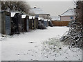
Garages in the snow
These garages are just off Bell Lane and last month have been fenced off to reduce vandalism I presume. The houses shown, are on Bishopthorpe Road.
Image: © Linda Bailey
Taken: 8 Feb 2007
0.08 miles
2
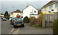
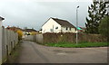
Bishop Manor Road, Bristol
At the junction with Bell Close (right).
Image: © Derek Harper
Taken: 7 Mar 2020
0.08 miles
4
Bishop Manor Road, Bristol
Looking left from Image], with some overlap and the road performing a graceful double bend.
Image: © Derek Harper
Taken: 7 Mar 2020
0.08 miles
5
Bell Close, Horfield
The houses in the cul-de-sac are off to the right; the houses ahead are on Bishop Manor Road.
Image: © Derek Harper
Taken: 7 Mar 2020
0.09 miles
6
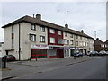
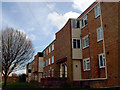
Block of Shops and Apartments, Bishopsthorpe Rd
This block of flats which is set back slightly from the road is Nos. 42 to 50 Bishopsthorpe Rd and has a row of shops which consist of
Top Chef Oriental Takeaway and Fish Bar
Artisan Coffee Shop (cake and sandwiches)
Sarah Norman Hair and Beauty
My Home Connect (National Trade Register)
RIA Newsagents and Convenience Store
The two shops on the extreme right appear to have been converted to residential units.
Image: © Nigel Mykura
Taken: 23 Feb 2013
0.09 miles
7
Garages, Bell Close, Horfield
Image is a detail of this scene, in the snow.
Image: © Derek Harper
Taken: 7 Mar 2020
0.09 miles
8
Tilling Road
A narrow road, but well used as one of the back routes into Southmead Hospital.
Image: © Linda Bailey
Taken: 2 Oct 2006
0.10 miles
9
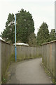
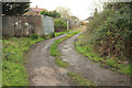
Path, Horfield
Linking Tilling Road (behind camera) and Bell Close.
Image: © Derek Harper
Taken: 7 Mar 2020
0.12 miles
10
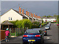
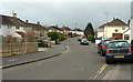
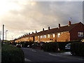
Looking along Rodbourne Road, Manor Farm
Looking north-east along Rodbourne Road. From where the red car on the edge of the photo is looking into the next square Image
Image: © Linda Bailey
Taken: 18 May 2006
0.12 miles