IMAGES TAKEN NEAR TO
Cranleigh Drive, SWANLEY, BR8 8NX
Introduction
This page details the photographs taken nearby to Cranleigh Drive, BR8 8NX by members of the Geograph project.
The Geograph project started in 2005 with the aim of publishing, organising and preserving representative images for every square kilometre of Great Britain, Ireland and the Isle of Man.

There are currently over 7.5m images from over14,400 individuals and you can help contribute to the project by visiting https://www.geograph.org.uk
Image Map
Images are licensed for reuse under creativecommons.org/licenses/by-sa/2.0
Notes
- Clicking on the map will re-center to the selected point.
- The higher the marker number, the further away the image location is from the centre of the postcode.
Image Listing (36 Images Found)
Images are licensed for reuse under creativecommons.org/licenses/by-sa/2.0
Image
Details
Distance
5
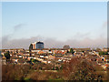
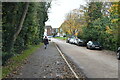
View to Swanley
A view from a bridleway the other side of the A20.
Image: © Stephen Craven
Taken: 26 Dec 2013
0.10 miles
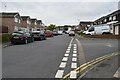
7
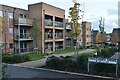
New apartments on former industrial site, Swanley
Image: © David Martin
Taken: 26 Nov 2022
0.12 miles
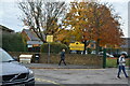
8
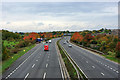
A20 looking west
The layby is the first pull-in after the M20 becomes the A20, and seems inadequate for its popularity.
Image: © Robin Webster
Taken: 29 Oct 2010
0.13 miles
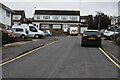
9
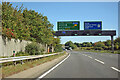
A20 eastbound, Swanley
A half mile to the start of the M20 at its junction 1.
Image: © Robin Webster
Taken: 27 Sep 2011
0.13 miles