IMAGES TAKEN NEAR TO
Mabel Road, SWANLEY, BR8 7SH
Introduction
This page details the photographs taken nearby to Mabel Road, BR8 7SH by members of the Geograph project.
The Geograph project started in 2005 with the aim of publishing, organising and preserving representative images for every square kilometre of Great Britain, Ireland and the Isle of Man.

There are currently over 7.5m images from over14,400 individuals and you can help contribute to the project by visiting https://www.geograph.org.uk
Image Map
Images are licensed for reuse under creativecommons.org/licenses/by-sa/2.0
Notes
- Clicking on the map will re-center to the selected point.
- The higher the marker number, the further away the image location is from the centre of the postcode.
Image Listing (16 Images Found)
Images are licensed for reuse under creativecommons.org/licenses/by-sa/2.0
Image
Details
Distance
4
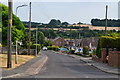
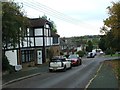
The edge of Hextable
This view is from Lower Road in Swanley Bottom and looks along the eastern edge of Hextable.
Image: © Marathon
Taken: 7 Jan 2012
0.07 miles
6
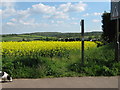
Footpath on Top Dartford Road
This footpath No.SD584 leads from B258 road past the Oil Seed Rape field downhill to Lower Road. Note, this crop is already 6ft tall in April.
Image: © David Anstiss
Taken: 29 Apr 2009
0.08 miles
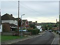
7
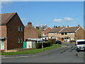
Houses on Fens Way, Hextable
The house on the left is on Lower Road.
Image: © Robin Webster
Taken: 8 Mar 2012
0.11 miles
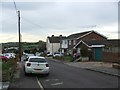
8

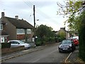
Houses on Lower Road, Hextable
These are actually on a residential road parallel with the foreground Lower Road, but it seems to have the same name.
Image: © Robin Webster
Taken: 8 Mar 2012
0.13 miles
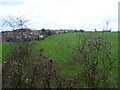
10
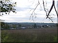
View of Hextable
As seen from near to a footpath from Rowhill Road towards Top Dartford Road.
Beyond Hextable is the Woods of Swanley Park.
Image: © David Anstiss
Taken: 30 Oct 2012
0.14 miles