IMAGES TAKEN NEAR TO
Bull Lane, CHISLEHURST, BR7 6NX
Introduction
This page details the photographs taken nearby to Bull Lane, BR7 6NX by members of the Geograph project.
The Geograph project started in 2005 with the aim of publishing, organising and preserving representative images for every square kilometre of Great Britain, Ireland and the Isle of Man.

There are currently over 7.5m images from over14,400 individuals and you can help contribute to the project by visiting https://www.geograph.org.uk
Image Map
Images are licensed for reuse under creativecommons.org/licenses/by-sa/2.0
Notes
- Clicking on the map will re-center to the selected point.
- The higher the marker number, the further away the image location is from the centre of the postcode.
Image Listing (83 Images Found)
Images are licensed for reuse under creativecommons.org/licenses/by-sa/2.0
Image
Details
Distance
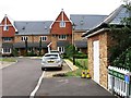
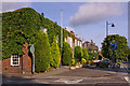
2

Chislehurst Business Centre
On the A222 Bromley Lane.
The building is Grade II listed but called Sunnymead!
See http://www.britishlistedbuildings.co.uk/en-358354-sunnymead-bromley for more details about the building.
Image: © David Anstiss
Taken: 15 Aug 2011
0.08 miles
3
Chislehurst Business Centre (2)
On the A222 Bromley Lane.
The building is Grade II listed but called Sunnymead!
See http://www.britishlistedbuildings.co.uk/en-358354-sunnymead-bromley for more details about the building.
Image: © David Anstiss
Taken: 15 Aug 2011
0.09 miles
4
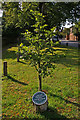
Millennium Tree
Alongside St Paul's Cray Road, this tree was planted in 2000 by the Chislehurst and St Paul's Cray Commons Conservators to mark the millennium.
Image: © Ian Capper
Taken: 28 Jul 2009
0.13 miles
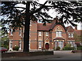
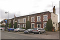
5
The Bulls Head Hotel
The present building dates largely from the early 19th century, with a northward extension in the late 19th century, although there has been a pub on the site since at least 1753, if not earlier. It was restored in the 1930s by Geoffrey Mullins, a local architect amongst whose work was St Francis Church in nearby Petts Wood (see Image), with various amendments to the frontage. It is grade II listed - for listing particulars see www.historicengland.org.uk/listing/the-list/list-entry/1186787.
Image: © Ian Capper
Taken: 28 Jul 2009
0.14 miles
6
The Bulls Head Hotel
The present building dates largely from the early 19th century, with a northward extension in the late 19th century, although there has been a pub on the site since at least 1753, if not earlier. It was restored in the 1930s by Geoffrey Mullins, a local architect amongst whose work was St Francis Church in nearby Petts Wood (see Image), with various amendments to the frontage. It is grade II listed - for listing particulars see www.historicengland.org.uk/listing/the-list/list-entry/1186787.
Image: © Ian Capper
Taken: 28 Jul 2009
0.14 miles
7
The Bulls Head Hotel
The present building dates largely from the early 19th century, with a northward extension in the late 19th century, although there has been a pub on the site since at least 1753, if not earlier. It was restored in the 1930s by Geoffrey Mullins, a local architect amongst whose work was St Francis Church in nearby Petts Wood (see Image), with various amendments to the frontage. It is grade II listed - for listing particulars see www.historicengland.org.uk/listing/the-list/list-entry/1186787.
Image: © Ian Capper
Taken: 9 Feb 2010
0.15 miles
8
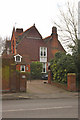
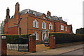
The Old Rectory, St Paul's Cray Road
One of a number of houses in the road designed by George Somers Leigh Clarke, it dates from 1877. Despite its name, it was never a rectory, although it was built at the request of the then Rector of St Nicholas' Church, Rev Francis Murray, as a clergy house. It is locally listed.
Image: © Ian Capper
Taken: 9 Feb 2010
0.15 miles
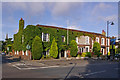
9
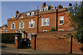
Chesil House, St Paul's Cray Road
Dating from around 1770, although the extension on the right is later, probably late 19th century. Grade II* listed - for listing particulars, see www.historicengland.org.uk/listing/the-list/list-entry/1299045.
Image: © Ian Capper
Taken: 28 Jul 2009
0.15 miles
10
Chesil House, St Paul's Cray Road
Dating from around 1770, although the extension on the right is later, probably late 19th century. Grade II* listed - for listing particulars, see www.historicengland.org.uk/listing/the-list/list-entry/1299045.
Image: © Ian Capper
Taken: 9 Feb 2010
0.15 miles