IMAGES TAKEN NEAR TO
Marsham Close, CHISLEHURST, BR7 6JD
Introduction
This page details the photographs taken nearby to Marsham Close, BR7 6JD by members of the Geograph project.
The Geograph project started in 2005 with the aim of publishing, organising and preserving representative images for every square kilometre of Great Britain, Ireland and the Isle of Man.

There are currently over 7.5m images from over14,400 individuals and you can help contribute to the project by visiting https://www.geograph.org.uk
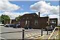
Image Map
Images are licensed for reuse under creativecommons.org/licenses/by-sa/2.0
Notes
- Clicking on the map will re-center to the selected point.
- The higher the marker number, the further away the image location is from the centre of the postcode.
Image Listing (51 Images Found)
Images are licensed for reuse under creativecommons.org/licenses/by-sa/2.0
Image
Details
Distance
1
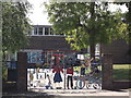
Gates to Red Hill Primary School
Stained glass style painted iron gates on Red Hill.
Image: © David Anstiss
Taken: 15 Aug 2011
0.06 miles
2
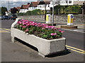
Cattle Water Trough, Red Hill
Grade II listed water trough.
This late C19 or early C20 cattle trough, was erected by the Metropolitan Drinking Fountain and Cattle Trough Association, is a handsome piece of street furniture which retains its three elements of cattle trough, dog trough and drinking fountain and is probably in its original location.
See http://www.britishlistedbuildings.co.uk/en-494740-water-trough-outside-the-former-white-ho for more details about the trough.
See also Image, for another photo and the nearby pub.
Image: © David Anstiss
Taken: 15 Aug 2011
0.09 miles
3
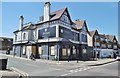
Chislehurst West, former pub
Formerly "White Horse" on White Horse Hill, now to be converted into apartments.
Image: © Mike Faherty
Taken: 27 May 2015
0.10 miles
4
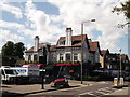
The Lounge, Chislehurst
Cocktail bar and music venue on the junction of Red Hill (on the right) and Victoria Road (on the left).
Was once the Plough Public House.
Image: © David Anstiss
Taken: 15 Aug 2011
0.10 miles
5
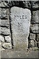
Old Milestone by the A208, White Horse Hill, Chislehurst
Carved stone post by the A208, in parish of CHISLEHURST (BROMLEY District), White Horse Hill, by No. 10, set in retaining stone wall of embankment, on East side of road. New Cross stone, erected by the New Cross turnpike trust in the 19th century.
Inscription reads:-
MILES
10
TO
LONDON
BRIDGE
Milestone Society National ID: KE_L10.
Image: © C Woodward
Taken: 1 Feb 2007
0.10 miles
6
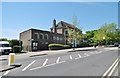
Chislehurst Library
On Red Hill: http://www.bromley.gov.uk/directory_record/1212653/chislehurst_library
Image: © Mike Faherty
Taken: 27 May 2015
0.10 miles
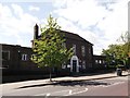
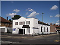
8
St Patrick's RC church, West Chislehurst
The church is on Red Hill.
Image: © Stephen Craven
Taken: 9 Jan 2010
0.11 miles
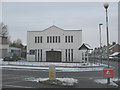
10
St. Patrick's Roman Catholic church, West Chislehurst
On the junction of Red Hill (on the left) and Albany Road (on the right).
Image: © David Anstiss
Taken: 15 Aug 2011
0.12 miles