IMAGES TAKEN NEAR TO
Manor Park, CHISLEHURST, BR7 5QF
Introduction
This page details the photographs taken nearby to Manor Park, BR7 5QF by members of the Geograph project.
The Geograph project started in 2005 with the aim of publishing, organising and preserving representative images for every square kilometre of Great Britain, Ireland and the Isle of Man.

There are currently over 7.5m images from over14,400 individuals and you can help contribute to the project by visiting https://www.geograph.org.uk
Image Map
Images are licensed for reuse under creativecommons.org/licenses/by-sa/2.0
Notes
- Clicking on the map will re-center to the selected point.
- The higher the marker number, the further away the image location is from the centre of the postcode.
Image Listing (31 Images Found)
Images are licensed for reuse under creativecommons.org/licenses/by-sa/2.0
Image
Details
Distance
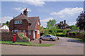
1
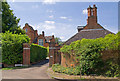
Walsingham, Manor Park
Walsingham is one of 5 large houses in Manor Park designed by George Somers Leigh Clarke. It dates from 1874, as does Walsingham Lodge (on the right), of the same architect. Both buildings are locally listed.
Image: © Ian Capper
Taken: 14 Jun 2011
0.02 miles
2
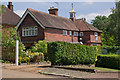
The Coach House, Manor Park
Coach house for Cookham Dene (see Image), and like the main house built in 1882 and designed by Sir Aston Webb. It is locally listed.
Image: © Ian Capper
Taken: 14 Jun 2011
0.08 miles
3
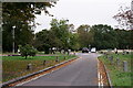
Chislehurst
Crown Lane, looking in the direction of The Crown Inn.
Image: © Peter Trimming
Taken: 4 Oct 2018
0.10 miles
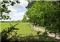
4
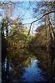
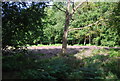
Flushers Pond
Situated beside the footpath between Image and Petts Wood.
It is part of the National Trust's Hawkwood Estate https://www.nationaltrust.org.uk/petts-wood-and-hawkwood
Image: © Glyn Baker
Taken: 17 Jan 2019
0.14 miles
5
Cookham Dene and The Lodge, Manor Park
Cookham Dene (the large house in the background) and its lodge (in the foreground) date from 1882 and were designed by Sir Aston Webb for his brother Edward Alfred Webb, a local historian. The main house is grade II listed - for listing particulars see www.historicengland.org.uk/listing/the-list/list-entry/1064397, with The Lodge similarly designated as a curtilage to the main building.
The post box, perhaps unsurprisingly given when the original houses in this road were built, is Victorian.
Image: © Ian Capper
Taken: 14 Jun 2011
0.18 miles
6
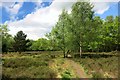
Footpath on The Gorse
The map labels this piece of land The Gorse, and it is quite a bit different from the adjoining Petts Wood.
The London Loop path feels very countrified all along this section even though suburban housing is never very far away.
Image: © Des Blenkinsopp
Taken: 12 May 2015
0.18 miles
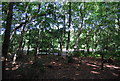
10
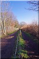
Divided "Highway"
The National Trust are to be congratulated in keeping cycles and horses on different paths to walkers. The right hand path is much less muddy not being churned up with hoofs and wheels
Image: © Glyn Baker
Taken: 17 Jan 2019
0.20 miles