IMAGES TAKEN NEAR TO
Yester Drive, CHISLEHURST, BR7 5LR
Introduction
This page details the photographs taken nearby to Yester Drive, BR7 5LR by members of the Geograph project.
The Geograph project started in 2005 with the aim of publishing, organising and preserving representative images for every square kilometre of Great Britain, Ireland and the Isle of Man.

There are currently over 7.5m images from over14,400 individuals and you can help contribute to the project by visiting https://www.geograph.org.uk
Image Map
Images are licensed for reuse under creativecommons.org/licenses/by-sa/2.0
Notes
- Clicking on the map will re-center to the selected point.
- The higher the marker number, the further away the image location is from the centre of the postcode.
Image Listing (43 Images Found)
Images are licensed for reuse under creativecommons.org/licenses/by-sa/2.0
Image
Details
Distance
1
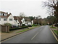
Yester Road, near Bromley
Yester Road is a residential road near Bromley, in the outer suburbs of south east London.
This image was taken on a dull and gloomy January afternoon. Deciduous trees were bare for the winter months.
Image: © Malc McDonald
Taken: 15 Jan 2022
0.06 miles
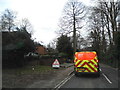
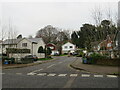
4
Width restriction on Yester Road, near Bromley
A width restriction on Yester Road, in the outer suburbs of south east London, enables cars and small vans to pass through but prevents larger vehicles such as buses or lorries from using this road. Signs clearly indicate that the maximum width of vehicle permitted is 7 feet.
This image was taken on a dull and gloomy January afternoon. Deciduous trees were bare for the winter months but this view includes a number of evergreen trees which keep their leaves all year round.
Image: © Malc McDonald
Taken: 15 Jan 2022
0.11 miles
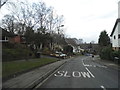
5
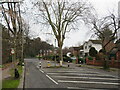
Sundridge Avenue, near Bromley
Sundridge Avenue is a suburban road near Bromley in south east London. Here, the road passes through a width restriction which allows cars and small vans through but presents larger vehicles such as buses and lorries from using this road.
This image was taken on a dull and gloomy January afternoon. Deciduous trees were bare for the winter months.
Image: © Malc McDonald
Taken: 15 Jan 2022
0.12 miles
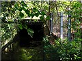
6

Sundridge Avenue, BR7 (2)
The green iron railings in the foreground (centre) mark where the Kyd Brook emerges from a culvert - see Image
Image: © Mike Quinn
Taken: 12 Oct 2010
0.12 miles
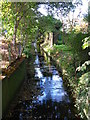
7
The Kyd Brook by Sundridge Avenue, BR7 (3)
Image: © Mike Quinn
Taken: 12 Oct 2010
0.13 miles
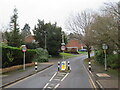
8
Bonar Place, near Bromley
Bonar Place is a residential cul-de-sac near Bromley, in the outer suburbs of south east London.
This image was taken on a dull and gloomy January afternoon. Deciduous trees were bare for the winter months, but evergreens still had their leaves.
Image: © Malc McDonald
Taken: 15 Jan 2022
0.13 miles
9
The Kyd Brook by Sundridge Avenue, BR7 (4)
Image: © Mike Quinn
Taken: 12 Oct 2010
0.13 miles
10
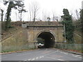
Railway bridge on Yester Road, near Bromley
Yester Road passes beneath an arch bridge carrying a railway line. The railway is the main line from London's Charing Cross terminus to Sevenoaks, Tunbridge Wells, Hastings, Ashford and the Kent coast.
This image was taken on a dull and gloomy January afternoon. Deciduous trees were bare for the winter months, but there are also some evergreens which keep their leaves all year round.
Image: © Malc McDonald
Taken: 15 Jan 2022
0.13 miles