IMAGES TAKEN NEAR TO
Becketts Close, ORPINGTON, BR6 9QJ
Introduction
This page details the photographs taken nearby to Becketts Close, BR6 9QJ by members of the Geograph project.
The Geograph project started in 2005 with the aim of publishing, organising and preserving representative images for every square kilometre of Great Britain, Ireland and the Isle of Man.

There are currently over 7.5m images from over14,400 individuals and you can help contribute to the project by visiting https://www.geograph.org.uk
Image Map
Images are licensed for reuse under creativecommons.org/licenses/by-sa/2.0
Notes
- Clicking on the map will re-center to the selected point.
- The higher the marker number, the further away the image location is from the centre of the postcode.
Image Listing (89 Images Found)
Images are licensed for reuse under creativecommons.org/licenses/by-sa/2.0
Image
Details
Distance
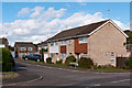
1
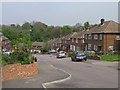
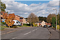
Maxwell Gardens
Built in 1955-56, on land owned by Arthur Gerald Maxwell. The Maxwells were for many years owners of nearby Tubbenden.
Image: © Ian Capper
Taken: 21 Apr 2009
0.03 miles
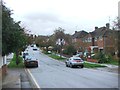
2
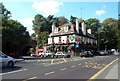
The Maxwell, A232 Station Road, Orpington BR6
To the left of the road is Tubbenden Lane. The A232 goes up the hill to the right, with Orpington station nearby.
Image: © Philip Talmage
Taken: 17 Sep 2005
0.08 miles
3
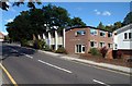
Orpington Baptist Church, BR6
In Tower Road; the A232 is just visible at the left of the picture. Built 1967 with a brick sanctuary added in 1977. No architectural prizes as far as is known ...
Image: © Philip Talmage
Taken: 17 Sep 2005
0.08 miles
4
Maxwell Gardens
Built in 1955-56, on land owned by Arthur Gerald Maxwell. The Maxwells were for many years owners of nearby Tubbenden.
Image: © Ian Capper
Taken: 21 Apr 2009
0.08 miles
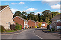
5
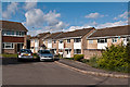
Arne Grove
Part of the early 1980s development of the former St Anne's and St Joseph's Orphanage sites. In the foreground is Stapleton Road.
Image: © Ian Capper
Taken: 16 Oct 2012
0.09 miles
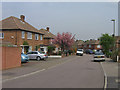
6
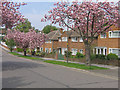
Ridgeway Crescent Gardens
Spring blossom in this 1950s development off Tubbenden Lane.
Image: © Ian Capper
Taken: 21 Apr 2009
0.10 miles
8
Stapleton Road
Part of the early 1980s development of the former St Anne's and St Joseph's Orphanage sites. In the background is the embankment carrying the Southeastern main railway line to Tonbridge.
Image: © Ian Capper
Taken: 16 Oct 2012
0.11 miles
9
Stapleton Road
Part of the early 1980s development of the former St Anne's and St Joseph's Orphanage sites.
Image: © Ian Capper
Taken: 16 Oct 2012
0.11 miles
10
Wayne Close
Part of the early 1980s development of the former St Anne's and St Joseph's Orphanage sites.
Image: © Ian Capper
Taken: 16 Oct 2012
0.13 miles