IMAGES TAKEN NEAR TO
Mitchell Road, ORPINGTON, BR6 9JT
Introduction
This page details the photographs taken nearby to Mitchell Road, BR6 9JT by members of the Geograph project.
The Geograph project started in 2005 with the aim of publishing, organising and preserving representative images for every square kilometre of Great Britain, Ireland and the Isle of Man.

There are currently over 7.5m images from over14,400 individuals and you can help contribute to the project by visiting https://www.geograph.org.uk
Image Map
Images are licensed for reuse under creativecommons.org/licenses/by-sa/2.0
Notes
- Clicking on the map will re-center to the selected point.
- The higher the marker number, the further away the image location is from the centre of the postcode.
Image Listing (51 Images Found)
Images are licensed for reuse under creativecommons.org/licenses/by-sa/2.0
Image
Details
Distance
1
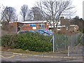
Holy Innocents Catholic Primary School
A voluntary aided Roman Catholic church school for 5 - 11 year olds.
Image: © Ian Capper
Taken: 12 Feb 2009
0.04 miles
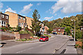
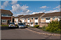
2
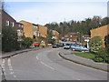
Stapleton Road
Part of a 1980s estate built on the site of a former orphanage.
Image: © Ian Capper
Taken: 12 Feb 2009
0.07 miles
3
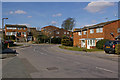
Stapleton Road
Part of a 1980s estate built on the site of a former orphanage. In the background, behind the houses, is part of Holy Innocents Catholic Primary School.
Image: © Ian Capper
Taken: 16 Mar 2010
0.07 miles
4
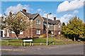
St Anne's Convent
A convent of the Sisters of Mercy, and the remaining link to the St Anne's Orphanage which (along with the St Joseph's Orphanage) until the late 1970s occupied the whole of this area. The building was the former presbytery for Holy Innocents' Church prior to a new one being built in 1981, at the same time as the new church.
Bishop Butt Close, in which it stands, commemorates Bishop Butt of the RC diocese of Southwark, who in 1887 founded the Southwark Diocesan Education Council & Rescue Society for poor and neglected children from South London, Kent, Surrey and Sussex, which 4 years later set up the St Joseph's Orphanage (later supplemented by the St Anne's Orphanage).
Image: © Ian Capper
Taken: 16 Oct 2012
0.07 miles
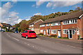
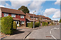
5
Stapleton Road
Part of the early 1980s development of the former St Anne's and St Joseph's Orphanage sites. In the background is the embankment carrying the Southeastern main railway line to Tonbridge.
Image: © Ian Capper
Taken: 16 Oct 2012
0.07 miles
6
Stapleton Road
Part of the early 1980s development of the former St Anne's and St Joseph's Orphanage sites. The trees behind are on the embankment carrying the Southeastern main railway line to Tonbridge.
Image: © Ian Capper
Taken: 16 Oct 2012
0.08 miles
7
Stapleton Road
Part of the early 1980s development of the former St Anne's and St Joseph's Orphanage sites.
Image: © Ian Capper
Taken: 16 Oct 2012
0.09 miles
8
Stapleton Road
Part of the early 1980s development of the former St Anne's and St Joseph's Orphanage sites.
Image: © Ian Capper
Taken: 16 Oct 2012
0.10 miles
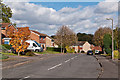
9
Wayne Close
Part of the early 1980s development of the former St Anne's and St Joseph's Orphanage sites.
Image: © Ian Capper
Taken: 16 Oct 2012
0.10 miles
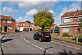
10
Stapleton Road
Part of the early 1980s development of the former St Ann's and St Joseph's Orphanage sites. In the background is St Anne's Convent.
Image: © Ian Capper
Taken: 16 Oct 2012
0.10 miles