IMAGES TAKEN NEAR TO
The Drive, ORPINGTON, BR6 9AP
Introduction
This page details the photographs taken nearby to The Drive, BR6 9AP by members of the Geograph project.
The Geograph project started in 2005 with the aim of publishing, organising and preserving representative images for every square kilometre of Great Britain, Ireland and the Isle of Man.

There are currently over 7.5m images from over14,400 individuals and you can help contribute to the project by visiting https://www.geograph.org.uk
Image Map
Images are licensed for reuse under creativecommons.org/licenses/by-sa/2.0
Notes
- Clicking on the map will re-center to the selected point.
- The higher the marker number, the further away the image location is from the centre of the postcode.
Image Listing (209 Images Found)
Images are licensed for reuse under creativecommons.org/licenses/by-sa/2.0
Image
Details
Distance
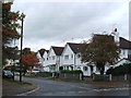
1
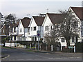
The Drive
A road developed soon after the first world war, connecting Sevenoaks Road with Station Road
Image: © Ian Capper
Taken: 12 Feb 2009
0.05 miles
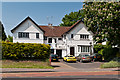
2
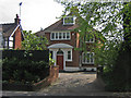
Station Road
This house, no 15, is locally listed.
Image: © Ian Capper
Taken: 23 Apr 2009
0.05 miles
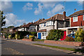
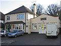
6
8-10 Sevenoaks Road
Pair of houses in Sevenoaks Road, built in the 1910s or so.
Image: © Ian Capper
Taken: 22 May 2012
0.07 miles
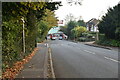
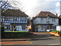
7
The Avenue
The continuation of Park Avenue (see Image) over Sevenoaks Road.
Image: © Ian Capper
Taken: 16 Oct 2012
0.07 miles
8
Orpington Conservative Association
This photo has been submitted to demonstrate political impartiality - see Image for the Liberal Club.
Image: © Ian Capper
Taken: 29 Nov 2007
0.07 miles
9
Orpington Liberal Club
One of Orpington's few claims to fame was the shock 1962 by-election victory by the then Liberals, which is still often referred to by political historians. This is their local headquarters. In the interests of political balance, see Image for the local Conservative Association's headquarters.
Image: © Ian Capper
Taken: 29 Nov 2007
0.08 miles
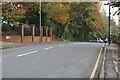
10
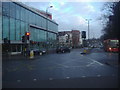
Station Road, Orpington
Tesco Metro is on the left, the roundabout on the High Street ahead.
Image: © David Howard
Taken: 12 Feb 2012
0.09 miles