IMAGES TAKEN NEAR TO
Felstead Road, ORPINGTON, BR6 9AD
Introduction
This page details the photographs taken nearby to Felstead Road, BR6 9AD by members of the Geograph project.
The Geograph project started in 2005 with the aim of publishing, organising and preserving representative images for every square kilometre of Great Britain, Ireland and the Isle of Man.

There are currently over 7.5m images from over14,400 individuals and you can help contribute to the project by visiting https://www.geograph.org.uk
Image Map (Loading...)


Getting Data...Please wait
Leaflet Map data © OpenStreetMap
Images are licensed for reuse under creativecommons.org/licenses/by-sa/2.0
Notes
- Clicking on the map will re-center to the selected point.
- The higher the marker number, the further away the image location is from the centre of the postcode.
Image Listing (46 Images Found)
Images are licensed for reuse under creativecommons.org/licenses/by-sa/2.0
Image
Details
Distance
1
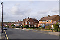
Hillcrest Road
Part of the development of this part of Orpington either side of the Second World War. This section of Hillcrest Road was built in the 1950s.
Image: © Ian Capper
Taken: 3 Nov 2010
0.07 miles
2
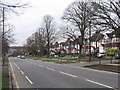
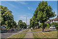
Spur Road
So called because it was a spur off the 1920s Orpington Bypass into the centre of Orpington.
Image: © Ian Capper
Taken: 11 Feb 2009
0.07 miles
3
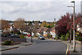
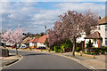
Felstead Road
One of the "public school" roads in this part of Orpington, built either side of the Second World War, this section being developed largely in the 1930s. In the background can be seen the roof of Tesco in central Orpington.
Image: © Ian Capper
Taken: 3 Nov 2010
0.07 miles
4
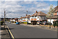
Hillcrest Road
Part of the development of this part of Orpington either side of the Second World War. This end of Hillcrest Road was built post-War.
Image: © Ian Capper
Taken: 17 Mar 2014
0.08 miles
5
Felstead Road
One of the "public school" roads in this part of Orpington, built either side of the Second World War, this section being developed largely in the 1930s.
Image: © Ian Capper
Taken: 17 Mar 2014
0.08 miles
6
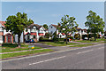
Spur Road
Built in the 1920s to link the new Orpington Bypass with the southern end of High Street, by what is now the War Memorial roundabout.
Originally unnumbered, it now forms part of the A232 which runs across the outer suburbs of south London from here through Croydon and Sutton to Ewell.
Image: © Ian Capper
Taken: 22 May 2012
0.09 miles
7
Spur Road
Built in the 1920s to link the new Orpington Bypass with the southern end of High Street, by what is now the War Memorial roundabout.
Originally unnumbered, it now forms part of the A232 which runs across the outer suburbs of south London from here through Croydon and Sutton to Ewell.
Image: © Ian Capper
Taken: 22 May 2012
0.09 miles
8
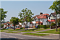
Felstead Road
This tree lined road leads from Park Avenue towards Spur Road.
Image: © David Anstiss
Taken: 24 Jul 2011
0.09 miles
9
Spur Road
Built in the 1920s to link the new Orpington Bypass with the southern end of High Street, by what is now the War Memorial roundabout. Originally unnumbered, it now forms part of the A232 which runs across the outer suburbs of south London from here through Croydon and Sutton to Ewell.
Image: © Ian Capper
Taken: 18 Jul 2014
0.12 miles
10
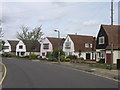
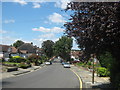
Felstead Road
One of a number of roads in this part of Orpington named after public schools. Felstead Road was started to be developed between the wars, partly along the route of what a 1920s map shows as the footpath leading from All Saints Church to Goddington. A group of houses in the road are of an unusual "dutch barn" design, as shown here.
Image: © Ian Capper
Taken: 25 Apr 2008
0.12 miles