IMAGES TAKEN NEAR TO
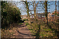
Stables End, ORPINGTON, BR6 8PD
Introduction
This page details the photographs taken nearby to Stables End, BR6 8PD by members of the Geograph project.
The Geograph project started in 2005 with the aim of publishing, organising and preserving representative images for every square kilometre of Great Britain, Ireland and the Isle of Man.

There are currently over 7.5m images from over14,400 individuals and you can help contribute to the project by visiting https://www.geograph.org.uk
Image Map
Images are licensed for reuse under creativecommons.org/licenses/by-sa/2.0
Notes
- Clicking on the map will re-center to the selected point.
- The higher the marker number, the further away the image location is from the centre of the postcode.
Image Listing (55 Images Found)
Images are licensed for reuse under creativecommons.org/licenses/by-sa/2.0
Image
Details
Distance
1
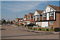
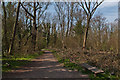
Darrick Wood
Semi-natural ancient woodland owned by Bromley Borough Council and designated a local nature reserve. In the background are houses in Masefield View.
Image: © Ian Capper
Taken: 29 Mar 2012
0.03 miles
2
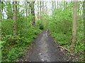
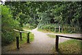
The London LOOP passing through Darrick Wood
The London LOOP here passes through Darrick Wood on its way from Keston and Farnborough to Crofton and Petts Wood. The board at the entrance gives its full name as 'Darrick & Newstead Woods Local Nature Reserve'.
Image: © Marathon
Taken: 23 Apr 2014
0.04 miles
3
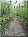
The London LOOP in Darrick Wood
The London LOOP here passes through Darrick Wood on its way from Petts Wood and Crofton to Farnborough and Keston. The board at the entrance gives its full name as 'Darrick & Newstead Woods Local Nature Reserve'.
Image: © Marathon
Taken: 23 Apr 2014
0.04 miles
4
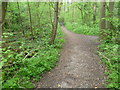
The London LOOP in Darrick Wood
The London LOOP here passes through Darrick Wood on its way from Petts Wood and Crofton to Farnborough and Keston.
Image: © Marathon
Taken: 23 Apr 2014
0.05 miles
5
Masefield View
1980s housing on the site of a former nursery. Seen here at its junction with Lysander Way.
Image: © Ian Capper
Taken: 29 Mar 2012
0.05 miles
6
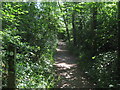
London Loop in Darrick Wood
The long distance path (London Outer Orbital Path) leads through the local nature reserve woodland from Crofton Avenue towards the A21 Farnborough Way.
Image: © David Anstiss
Taken: 31 Jul 2011
0.06 miles
7
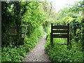
The London LOOP entering Darrick Wood
The London LOOP here passes through Darrick Wood on its way from Petts Wood and Crofton to Farnborough and Keston. The board on the right gives its full name as 'Darrick & Newstead Woods Local Nature Reserve'.
Image: © Marathon
Taken: 23 Apr 2014
0.06 miles
8
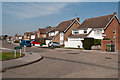
Partridge Drive
1980s housing on the site of a former nursery. Seen here at its junction with Lysander Way. On the right is the start of a footpath that leads to Crofton Avenue.
Image: © Ian Capper
Taken: 29 Mar 2012
0.08 miles
9
Darrick Wood
Semi-natural ancient woodland owned by Bromley Borough Council and designated a local nature reserve.
Image: © Ian Capper
Taken: 29 Mar 2012
0.10 miles
10
Footpath Junction in Darrick Woods
The London Loop http://www.walklondon.org.uk/route.asp?R=5 waymarks follow a serpentine route it would have been much quicker to follow my instinct and compass and take the permissive paths rather than following the waymarks!
Image: © Glyn Baker
Taken: 21 Aug 2012
0.10 miles