IMAGES TAKEN NEAR TO
Park Avenue, ORPINGTON, BR6 8LJ
Introduction
This page details the photographs taken nearby to Park Avenue, BR6 8LJ by members of the Geograph project.
The Geograph project started in 2005 with the aim of publishing, organising and preserving representative images for every square kilometre of Great Britain, Ireland and the Isle of Man.

There are currently over 7.5m images from over14,400 individuals and you can help contribute to the project by visiting https://www.geograph.org.uk
Image Map (Loading...)


Getting Data...Please wait
Leaflet Map data © OpenStreetMap
Images are licensed for reuse under creativecommons.org/licenses/by-sa/2.0
Notes
- Clicking on the map will re-center to the selected point.
- The higher the marker number, the further away the image location is from the centre of the postcode.
Image Listing (12 Images Found)
Images are licensed for reuse under creativecommons.org/licenses/by-sa/2.0
Image
Details
Distance
1
A friendly estate, Locksbottom
Park Avenue, BR6.
Image: © Mike Quinn
Taken: 12 Mar 2010
0.06 miles
2
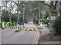
House at Farnborough Park
Farnborough Park is very exclusive. The only way in seems to be from Crofton Road via Park Avenue, and there are private traffic lights and rising barriers to stop undesirables from entering. This is one of the more impressive houses and gardens, seen from Park Avenue and next to Pokeridden Wood.
Image: © Marathon
Taken: 23 Apr 2014
0.13 miles
3
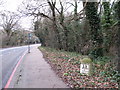
The A21 northwest of Locksbottom
Shows the location of Image
Image: © Mike Quinn
Taken: 11 Jan 2011
0.15 miles
4
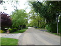
Park Avenue, Farnborough Park
Farnborough Park is so exclusive that I cannot imagine why speed humps are needed. The only way in seems to be from Crofton Road via Park Avenue, and there are private traffic lights and rising barriers to stop undesirables from entering.
In this view looking along Park Avenue, Pokeridden Wood is on the right.
Image: © Marathon
Taken: 23 Apr 2014
0.17 miles
5
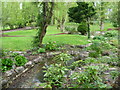
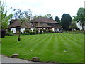
Garden in Park Avenue, Farnborough Park
Farnborough Park is very exclusive. The only way in seems to be from Crofton Road via Park Avenue, and there are private traffic lights and rising barriers to stop undesirables from entering. This is one of the more impressive gardens seen from Park Avenue and next to Pokeridden Wood.
Image: © Marathon
Taken: 23 Apr 2014
0.18 miles
6

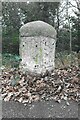
Milestone on the A21 northwest of Locksbottom
Image: © Mike Quinn
Taken: 11 Jan 2011
0.21 miles
7

Milestone. London Bridge-13, Farnborough-1.
Located in verge at south east side of Farnborough Common. Incorporates an Ordnance Survey Cut Bench Mark at the base of the north face. (Ref.BM4704)
Image: © Alan Barlow
Taken: 18 Aug 2010
0.21 miles
8

Old Milestone by the A21, Farnborough Common, Bromley parish
Metal plate attached to stone post by the A21, in parish of BROMLEY (BROMLEY District), Farnborough Common, Locks Bottom, 130m West of Fantail junction, on edge of shrubbery, behind path, on Northeast side of road. Bromley marker, erected by the Sevenoaks turnpike trust in the 19th century.
Inscription reads:-
: 1 / MILE / TO / FARNBORO : : 13 / MILES / TO / LONDON /BRIDGE :
Grade II listed.
List Entry Number: 1299025 https://historicengland.org.uk/listing/the-list/list-entry/1299025
Milestone Society National ID: KE_LBFA13.
Image: © C Woodward
Taken: 16 Mar 2007
0.22 miles
9
Old Milestone by A21, Farnborough Common, Locks Bottom, 130m West of Fantail junction
The Milestone is located on edge of shrubbery, behind path on the North of the road. Parish of Bromley (Bromley District). Metal plate attached to stone post, Bromley marker design, erected by the Sevenoaks turnpike trust in the 19th Century. An earlier photograph can be found here: https://www.geograph.org.uk/photo/6061421
Inscription reads:-
(1 / MILE / TO / FARNBORO) : : (13 / MILES / TO / LONDON /BRIDGE)
Grade II listed. List Entry Number: 1299025 https://historicengland.org.uk/listing/the-list/list-entry/1299025
Milestone Society National ID: KE_LBFA13
Image: © Andrew Knorpel
Taken: 1 Jan 2023
0.22 miles
10

Oakley Hotel for Cats, Oakley Road BR2
(inset: the sign)
Image: © Philip Talmage
Taken: 31 Aug 2005
0.23 miles