IMAGES TAKEN NEAR TO
Drayton Avenue, ORPINGTON, BR6 8JW
Introduction
This page details the photographs taken nearby to Drayton Avenue, BR6 8JW by members of the Geograph project.
The Geograph project started in 2005 with the aim of publishing, organising and preserving representative images for every square kilometre of Great Britain, Ireland and the Isle of Man.

There are currently over 7.5m images from over14,400 individuals and you can help contribute to the project by visiting https://www.geograph.org.uk
Image Map
Images are licensed for reuse under creativecommons.org/licenses/by-sa/2.0
Notes
- Clicking on the map will re-center to the selected point.
- The higher the marker number, the further away the image location is from the centre of the postcode.
Image Listing (105 Images Found)
Images are licensed for reuse under creativecommons.org/licenses/by-sa/2.0
Image
Details
Distance
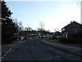
1
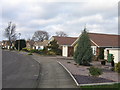
Drayton Avenue
The Orpington area is full of bungalows! These ones date from the 1960s, built on land at the edge of Crofton Heath.
Image: © Ian Capper
Taken: 25 Jan 2008
0.03 miles
2
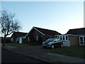
Bungalows on Lansdowne Avenue, Orpington
Image: © David Howard
Taken: 29 Dec 2013
0.06 miles
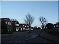
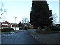
4
Drayton Avenue from Fairbank Avenue, Orpington
Image: © David Howard
Taken: 29 Dec 2013
0.08 miles
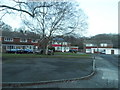
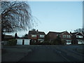
10
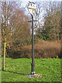
Sign at Crofton
This is sign is on a small patch of green in what is otherwise continuous housing on the A232 between Orpington and Locksbottom.
See Image for context and Image for detail of the sign, including the wording of the plaque visible at its foot.
Image: © Ian Capper
Taken: 22 Jan 2008
0.15 miles