IMAGES TAKEN NEAR TO
Pilkington Road, ORPINGTON, BR6 8HR
Introduction
This page details the photographs taken nearby to Pilkington Road, BR6 8HR by members of the Geograph project.
The Geograph project started in 2005 with the aim of publishing, organising and preserving representative images for every square kilometre of Great Britain, Ireland and the Isle of Man.

There are currently over 7.5m images from over14,400 individuals and you can help contribute to the project by visiting https://www.geograph.org.uk
Image Map
Images are licensed for reuse under creativecommons.org/licenses/by-sa/2.0
Notes
- Clicking on the map will re-center to the selected point.
- The higher the marker number, the further away the image location is from the centre of the postcode.
Image Listing (95 Images Found)
Images are licensed for reuse under creativecommons.org/licenses/by-sa/2.0
Image
Details
Distance
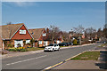
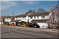
1
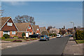
Pilkington Road
1970s housing on previous woodland, shown on maps as High Wood.
Image: © Ian Capper
Taken: 29 Mar 2012
0.01 miles
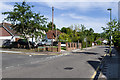
2
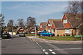
Mosslea Road
1970s housing on previous woodland, shown on maps as High Wood. Seen here at its junction with Pilkington Road.
Image: © Ian Capper
Taken: 29 Mar 2012
0.03 miles
3
Mosslea Road
1970s housing on previous woodland, shown on maps as High Wood.
Image: © Ian Capper
Taken: 29 Mar 2012
0.03 miles
4
Pondfield Road
1970s housing on previous woodland, shown on maps as High Wood, which (of relevance to this road) included a pond.
Image: © Ian Capper
Taken: 29 Mar 2012
0.04 miles
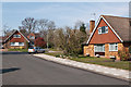
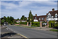
5
Lovibonds Avenue
Mid 19th century maps show a footpath here; by the end of the century it is shown as a road, but it is not until a 1930s map is development shown on its south side. The north side (seen here) remained a combination of open land and woodland until developed in the 1970s.
The Lovibond family were the owners of much of the land here.
Image: © Ian Capper
Taken: 29 Mar 2012
0.05 miles
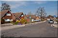
6
Lovibonds Avenue
Mid 19th century maps show a footpath here; by the end of the century it is shown as a road, but it is not until a 1930s map is development shown on its south side (the houses here, for example). The north side remained a combination of open land and woodland until developed in the 1970s.
The Lovibond family were the owners of much of the land here.
Image: © Ian Capper
Taken: 3 Jun 2013
0.07 miles
7
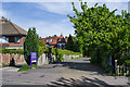
Darrick Wood Swimming Pool
Entrance to Darrick Wood Swimming Pool off Lovibonds Avenue. Originally built in 1928, they now form part of Darrick Wood School.
Image: © Ian Capper
Taken: 3 Jun 2013
0.12 miles
8
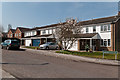
Sloane Gardens
1980s housing on the site of a former nursery.
Image: © Ian Capper
Taken: 29 Mar 2012
0.13 miles
9
Partridge Drive
1980s housing on the site of a former nursery.
Image: © Ian Capper
Taken: 29 Mar 2012
0.13 miles
10
Mada Road
Road linking Crofton Road and Lovibonds Avenue developed around 1960.
Image: © Ian Capper
Taken: 3 Jun 2013
0.14 miles