IMAGES TAKEN NEAR TO
Percival Road, ORPINGTON, BR6 8HL
Introduction
This page details the photographs taken nearby to Percival Road, BR6 8HL by members of the Geograph project.
The Geograph project started in 2005 with the aim of publishing, organising and preserving representative images for every square kilometre of Great Britain, Ireland and the Isle of Man.

There are currently over 7.5m images from over14,400 individuals and you can help contribute to the project by visiting https://www.geograph.org.uk
Image Map
Images are licensed for reuse under creativecommons.org/licenses/by-sa/2.0
Notes
- Clicking on the map will re-center to the selected point.
- The higher the marker number, the further away the image location is from the centre of the postcode.
Image Listing (78 Images Found)
Images are licensed for reuse under creativecommons.org/licenses/by-sa/2.0
Image
Details
Distance
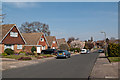
1
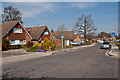
Pondfield Road
1970s housing on previous woodland, shown on maps as High Wood, which (of relevance to this road) included a pond.
Image: © Ian Capper
Taken: 29 Mar 2012
0.06 miles
5
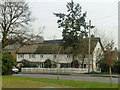
Thatched cottages, Crofton Road
A row of originally three cottages. The two on the left seem to have only one front gate now.
Image: © Robin Webster
Taken: 14 Feb 2012
0.07 miles
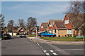
6
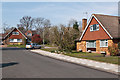
Mosslea Road
1970s housing on previous woodland, shown on maps as High Wood.
Image: © Ian Capper
Taken: 29 Mar 2012
0.08 miles
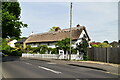
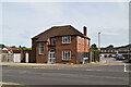
8
The Cottage, Crofton Road
This 18th Century thatched cottage (imaginatively called "The Cottage"), dates from a time when this was presumably a country lane, not the busy A road it now is. The immediate area was largely undeveloped, most of the housing around being post war.
Image: © Ian Capper
Taken: 25 Jan 2008
0.09 miles
9
Pilkington Road
1970s housing on previous woodland, shown on maps as High Wood.
Image: © Ian Capper
Taken: 29 Mar 2012
0.09 miles
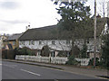
10
Mosslea Road
1970s housing on previous woodland, shown on maps as High Wood. Seen here at its junction with Pilkington Road.
Image: © Ian Capper
Taken: 29 Mar 2012
0.10 miles