IMAGES TAKEN NEAR TO
Crofton Avenue, ORPINGTON, BR6 8DZ
Introduction
This page details the photographs taken nearby to Crofton Avenue, BR6 8DZ by members of the Geograph project.
The Geograph project started in 2005 with the aim of publishing, organising and preserving representative images for every square kilometre of Great Britain, Ireland and the Isle of Man.

There are currently over 7.5m images from over14,400 individuals and you can help contribute to the project by visiting https://www.geograph.org.uk
Image Map
Images are licensed for reuse under creativecommons.org/licenses/by-sa/2.0
Notes
- Clicking on the map will re-center to the selected point.
- The higher the marker number, the further away the image location is from the centre of the postcode.
Image Listing (70 Images Found)
Images are licensed for reuse under creativecommons.org/licenses/by-sa/2.0
Image
Details
Distance
1
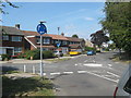
Roundabout on Crofton Avenue
Crofton Avenue leads from Rusland Avenue towards Crofton Road.
Lovibonds Avenue heads left towards Darrick Wood schools.
Image: © David Anstiss
Taken: 31 Jul 2011
0.04 miles
2
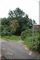
The London Loop Enters Crofton Avenue
The long distance path http://www.walklondon.org.uk/route.asp?R=5 exits Image nature reserve
and enters suburbia.
Image: © Glyn Baker
Taken: 21 Aug 2012
0.08 miles
3
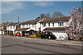
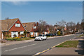
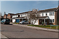
Partridge Drive
1980s housing on the site of a former nursery.
Image: © Ian Capper
Taken: 29 Mar 2012
0.09 miles
4
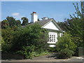
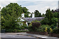
The Lodge, Crofton
Grade II Listed building on Crofton Avenue.
See http://www.britishlistedbuildings.co.uk/en-358419-the-lodge-35-bromley for more details about the building.
Image: © David Anstiss
Taken: 31 Jul 2011
0.10 miles
5
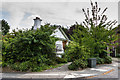
The Lodge
Former lodge to the now demolished Crofton Hall, situated in Crofton Avenue. Dating from c.1860, it is grade II listed - see www.historicengland.org.uk/listing/the-list/list-entry/1068864.
Image: © Ian Capper
Taken: 8 Aug 2013
0.11 miles
6
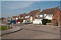
Lovibonds Avenue
Mid 19th century maps show a footpath here; by the end of the century it is shown as a road, but it is not until a 1930s map is development shown on its south side. The north side (seen here) remained a combination of open land and woodland until developed in the 1970s.
The Lovibond family were the owners of much of the land here.
Image: © Ian Capper
Taken: 29 Mar 2012
0.11 miles
7
The Lodge
Former lodge to the now demolished Crofton Hall, situated in Crofton Avenue. Dating from c.1860, it is grade II listed - see www.historicengland.org.uk/listing/the-list/list-entry/1068864.
Image: © Ian Capper
Taken: 8 Aug 2013
0.11 miles
8
Partridge Drive
1980s housing on the site of a former nursery. Seen here at its junction with Lysander Way. On the right is the start of a footpath that leads to Crofton Avenue.
Image: © Ian Capper
Taken: 29 Mar 2012
0.11 miles
9
Sloane Gardens
1980s housing on the site of a former nursery.
Image: © Ian Capper
Taken: 29 Mar 2012
0.11 miles
10
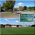
Newstead Wood School, Orpington, BR6
A selective girls' school in the London Borough of Bromley; see http://www.newsteadwood.bromley.sch.uk/
Image: © Philip Talmage
Taken: 17 Sep 2005
0.12 miles