IMAGES TAKEN NEAR TO
Downs View Close, ORPINGTON, BR6 7SU
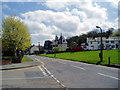
Introduction
This page details the photographs taken nearby to Downs View Close, BR6 7SU by members of the Geograph project.
The Geograph project started in 2005 with the aim of publishing, organising and preserving representative images for every square kilometre of Great Britain, Ireland and the Isle of Man.

There are currently over 7.5m images from over14,400 individuals and you can help contribute to the project by visiting https://www.geograph.org.uk
Image Map
Images are licensed for reuse under creativecommons.org/licenses/by-sa/2.0
Notes
- Clicking on the map will re-center to the selected point.
- The higher the marker number, the further away the image location is from the centre of the postcode.
Image Listing (62 Images Found)
Images are licensed for reuse under creativecommons.org/licenses/by-sa/2.0
Image
Details
Distance
1
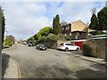
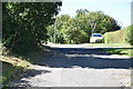
Green Street Green Walk in Pratt's Bottom
This path leads down from Stonehouse Road byway to Rushmore Hill. It is also a part of a circular walk organised by Transport For London around Pratt's Bottom and Chelsfield.
See http://www.tfl.gov.uk/tfl/gettingaround/walkfinder/walkdetails.asp?id=59 for more details. (Although do not follow the link for the map - You won't find it ???!!!)
Image: © David Anstiss
Taken: 8 Nov 2009
0.04 miles
2
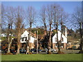
Downs View Close, Pratts Bottom
Downs View Close is a residential cul-de-sac in the village of Pratts Bottom, on the outer fringe of South East London.
Image: © Malc McDonald
Taken: 9 Mar 2019
0.04 miles
3
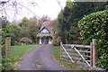
Edgehill House, Pratt's Bottom
At the end of Stonehouse Road.
Image: © David Anstiss
Taken: 8 Nov 2009
0.05 miles
4
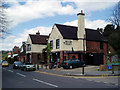
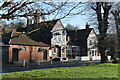
The 'Bulls Head', Pratts Bottom, near Orpington
Image: © Dr Neil Clifton
Taken: 3 May 2006
0.05 miles
6
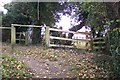
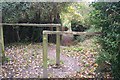
Footpath junction near Pratt's Bottom
A path from Rushmore Hill climbs up and then heads left towards Stonehouse Road. Another path heads right across a field then through Pratt's Grove (woodland) and then onto Stonehouse Lane.
Image: © David Anstiss
Taken: 8 Nov 2009
0.05 miles
7
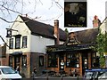
Bull's Head, Pratt's Bottom
This pub beside the village green is the original centre of the village, not the roundabout on Sevenoaks Road which is 500 metres further north. Of course the pub sign is not meant to look Patrick Moore, astronomer he wears his monocle in the other eye!
Image: © Roger W Haworth
Taken: 29 Mar 2006
0.06 miles
8
The Bull's Head at Pratt's Bottom
The photograph was taken from the village green.
Image: © Marathon
Taken: 9 Jan 2011
0.06 miles