IMAGES TAKEN NEAR TO
Bucks Cross Road, ORPINGTON, BR6 7RJ
Introduction
This page details the photographs taken nearby to Bucks Cross Road, BR6 7RJ by members of the Geograph project.
The Geograph project started in 2005 with the aim of publishing, organising and preserving representative images for every square kilometre of Great Britain, Ireland and the Isle of Man.

There are currently over 7.5m images from over14,400 individuals and you can help contribute to the project by visiting https://www.geograph.org.uk
Image Map (Loading...)


Getting Data...Please wait
Leaflet Map data © OpenStreetMap
Images are licensed for reuse under creativecommons.org/licenses/by-sa/2.0
Notes
- Clicking on the map will re-center to the selected point.
- The higher the marker number, the further away the image location is from the centre of the postcode.
Image Listing (54 Images Found)
Images are licensed for reuse under creativecommons.org/licenses/by-sa/2.0
Image
Details
Distance
7
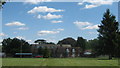
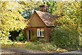
Chelsfield Park Hospital
This hospital on Bucks Cross Road is currently part of BMI Healthcare (a private hospital company).
In front of the main building is Chelsfield House. A grade II listed house, that was once a rectory.
See http://www.bmihealthcare.co.uk/hospital/about-the-hospital?p_hosp_name=BMI Chelsfield Park Hospital&p_hosp_id=241&in_page=About the hospital for more details about the hospital.
Image: © David Anstiss
Taken: 24 Jul 2011
0.07 miles
8
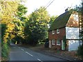
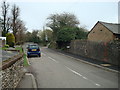
Skibbs Lane, Chelsfield
The simple village sign seen here on the right is at the junction of Skibbs Lane and Bucks Cross Road.
Image: © Marathon
Taken: 16 Dec 2012
0.09 miles
9
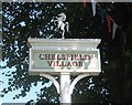
Close-up of Chelsfield Village Sign
A close-up of Image
Shows a white sign with a white horse on top.
The horse is the symbol of Kent.
Chelsfield used to be part of the County of Kent, but since the creation of the Greater London Council in 1965, it transferred to the London Borough of Bromley.
Image: © David Anstiss
Taken: 24 Jul 2011
0.09 miles
10
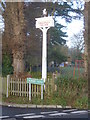
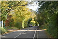
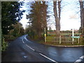
Chelsfield village sign
The simple village sign seen here is at the junction of Skibbs Lane to the left and Bucks Cross Road to the right. The prancing horse is the symbol of Kent although Chelsfield is now in the London Borough of Bromley.
Image: © Marathon
Taken: 16 Dec 2012
0.09 miles