IMAGES TAKEN NEAR TO
Luxted Road, ORPINGTON, BR6 7LA
Introduction
This page details the photographs taken nearby to Luxted Road, BR6 7LA by members of the Geograph project.
The Geograph project started in 2005 with the aim of publishing, organising and preserving representative images for every square kilometre of Great Britain, Ireland and the Isle of Man.

There are currently over 7.5m images from over14,400 individuals and you can help contribute to the project by visiting https://www.geograph.org.uk
Image Map
Images are licensed for reuse under creativecommons.org/licenses/by-sa/2.0
Notes
- Clicking on the map will re-center to the selected point.
- The higher the marker number, the further away the image location is from the centre of the postcode.
Image Listing (55 Images Found)
Images are licensed for reuse under creativecommons.org/licenses/by-sa/2.0
Image
Details
Distance
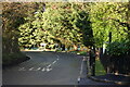
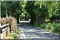
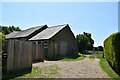
4
Luxted Road
With Coal Tax Post no 188 (see Image) on the left.
Image: © Ian Capper
Taken: 20 Aug 2012
0.08 miles
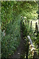
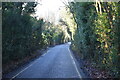
6
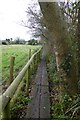
Path on boards
Heading towards Luxted near Single Street.
Image: © DS Pugh
Taken: 12 Dec 2015
0.09 miles
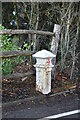
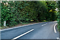
8
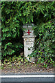
Coal Tax Post no 188
This Coal Tax Post (no 188 on the list linked to below) is well hidden in a hedge alongside Luxted Road. For context see Image
Image: © Ian Capper
Taken: 20 Aug 2012
0.09 miles