IMAGES TAKEN NEAR TO
Farthing Street, ORPINGTON, BR6 7JB
Introduction
This page details the photographs taken nearby to Farthing Street, BR6 7JB by members of the Geograph project.
The Geograph project started in 2005 with the aim of publishing, organising and preserving representative images for every square kilometre of Great Britain, Ireland and the Isle of Man.

There are currently over 7.5m images from over14,400 individuals and you can help contribute to the project by visiting https://www.geograph.org.uk
Image Map (Loading...)


Getting Data...Please wait
Leaflet Map data © OpenStreetMap
Images are licensed for reuse under creativecommons.org/licenses/by-sa/2.0
Notes
- Clicking on the map will re-center to the selected point.
- The higher the marker number, the further away the image location is from the centre of the postcode.
Image Listing (58 Images Found)
Images are licensed for reuse under creativecommons.org/licenses/by-sa/2.0
Image
Details
Distance
1
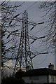
Pylon line passing over house, near Downe
Image: © Christopher Hilton
Taken: 30 Mar 2008
0.04 miles
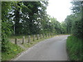
2
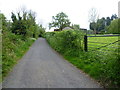
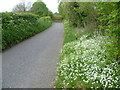
Farthing Street
This is the delightfully named Farthing Street which is also delightfully free from traffic. It is hard to believe that this remote country lane is still in Greater London - the London Borough of Bromley in fact. Bogey Lane is just behind where I am standing. The latter is an ancient sunken trackway which is followed here by the London LOOP between High Elms and Keston.
Image: © Marathon
Taken: 23 Apr 2014
0.04 miles
3
Farthing Street
This is the delightfully named Farthing Street which is also delightfully free from traffic. It is hard to believe that this remote country lane is still in Greater London - the London Borough of Bromley in fact. Bogey Lane is just behind where I am standing. The latter is an ancient sunken trackway which is followed here by the London LOOP between High Elms and Keston.
Image: © Marathon
Taken: 23 Apr 2014
0.04 miles

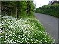
6
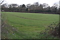
Sloping field near Farthing Street
Taken at the point where the high voltage power lines cross the footpath.
Image: © David Martin
Taken: 27 Feb 2023
0.08 miles
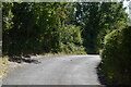
7
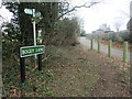
Farthing Street meets Bogey Lane
Bogey Lane is an ancient sunken trackway which is followed here by the London LOOP between Keston and High Elms. It can become very muddy so the official advice is to follow the field edge path just uphill to the south. In this photograph the start of Bogey Lane is seen from Farthing Street. It is hard to believe that this remote path is still in Greater London but in fact it is in the London Borough of Bromley. See also www.geograph.org.uk/photo/3949662
Image: © Marathon
Taken: 11 Feb 2023
0.08 miles
8
The London Loop leaves Farthing Street
The long distance path (London Outer Orbital Path) leads left along a permissive track towards High Elms Country Park.
Farthing Street leads from Downe Lane towards Rookery Road.
Image: © David Anstiss
Taken: 31 Jul 2011
0.08 miles
9
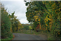
Bogey Lane is blocked off
The junction of Farthing Street with Bogey Lane, which fairly recently has been blocked off to large vehicles. It is the local course of the London Loop long distance path.
Image: © Robin Webster
Taken: 30 Oct 2011
0.08 miles
10
Farthing Street looking towards the London LOOP
This is the delightfully named Farthing Street which is also delightfully free from traffic. It is hard to believe that this remote country lane is still in Greater London - the London Borough of Bromley in fact. Bogey Lane comes out on the bend ahead. This is an ancient sunken trackway which is followed by the LOOP which then continues down Farthing Street to the busy Shire Lane.
Image: © Marathon
Taken: 23 Apr 2014
0.08 miles