IMAGES TAKEN NEAR TO
Cocksett Avenue, ORPINGTON, BR6 7HE
Introduction
This page details the photographs taken nearby to Cocksett Avenue, BR6 7HE by members of the Geograph project.
The Geograph project started in 2005 with the aim of publishing, organising and preserving representative images for every square kilometre of Great Britain, Ireland and the Isle of Man.

There are currently over 7.5m images from over14,400 individuals and you can help contribute to the project by visiting https://www.geograph.org.uk
Image Map
Images are licensed for reuse under creativecommons.org/licenses/by-sa/2.0
Notes
- Clicking on the map will re-center to the selected point.
- The higher the marker number, the further away the image location is from the centre of the postcode.
Image Listing (72 Images Found)
Images are licensed for reuse under creativecommons.org/licenses/by-sa/2.0
Image
Details
Distance
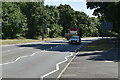
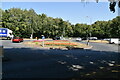
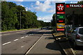
3
Farnborough Hill B2158 Approaching A21 roundabout
Image: © Martin Dawes
Taken: 8 Oct 2017
0.09 miles
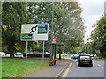
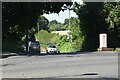
4
Roundabout on Farnborough Way, Orpington
Image: © David Howard
Taken: 30 Sep 2012
0.09 miles
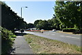
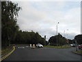
9
Farnborough Way, A21
Farnborough Way is the northern of two stretches of arterial road that take the A21 Hastings route past the villages of Farnborough and Green Street Green.
Image: © Christopher Hilton
Taken: 23 Aug 2015
0.10 miles
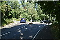
10
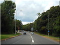
A21 Farnborough By-Pass
A view of the A21 passing through the outer fringes of south east London. This image was taken on a Sunday afternoon while traffic was fairly light.
Image: © Malc McDonald
Taken: 31 Jul 2016
0.10 miles