IMAGES TAKEN NEAR TO
High Street, ORPINGTON, BR6 7BG
Introduction
This page details the photographs taken nearby to High Street, BR6 7BG by members of the Geograph project.
The Geograph project started in 2005 with the aim of publishing, organising and preserving representative images for every square kilometre of Great Britain, Ireland and the Isle of Man.

There are currently over 7.5m images from over14,400 individuals and you can help contribute to the project by visiting https://www.geograph.org.uk
Image Map (Loading...)


Getting Data...Please wait
Leaflet Map data © OpenStreetMap
Images are licensed for reuse under creativecommons.org/licenses/by-sa/2.0
Notes
- Clicking on the map will re-center to the selected point.
- The higher the marker number, the further away the image location is from the centre of the postcode.
Image Listing (114 Images Found)
Images are licensed for reuse under creativecommons.org/licenses/by-sa/2.0
Image
Details
Distance
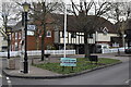
3
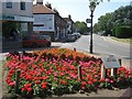
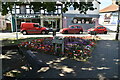
Flower Display beside Farnborough High Street
Bright annual display at the junction of Church Road and the High Street.
Image: © David Anstiss
Taken: 31 Jul 2011
0.02 miles
6
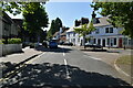
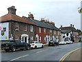
Farnborough High Street
The high street passing through the village of Farnborough, near Orpington.
Image: © Malc McDonald
Taken: 31 Jul 2016
0.02 miles
8
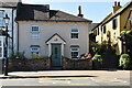
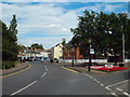
Traffic island in the old village centre, Farnborough
Image: © David Martin
Taken: 27 Feb 2023
0.02 miles
9
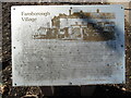
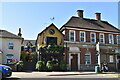
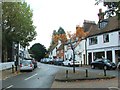
Farnborough Village Information Board
This information board, erected by the London Borough of Bromley, is located on the corner of
High Street and Church Road. The image at the top shows the George & Dragon Inn in High
Street which was replaced by The George Inn in 1937. That closed in 2003 and then demolished, it being replaced by residential cottages and flats. The board has the following wording:
Farnborough Village
Left column
The name of the village derives from Fearnbiorginga or village among the ferns on the hill.
Records date from 862AD when Ethelbert, King of Wessex gave away 950 acres at
Farnborough. The village was not mentioned in the Domesday Book although the manor
existed in the Middle Ages and in the 1200s was held by Simon de Montfort.
The village developed on the main road from London to Hastings which originally ran via
Church Road and Old Hill. The George Pub existed in the 16th Century, and was used as a
coaching inn. Coaches and horses were later accommodated at The Change of Horses.
Church Road retains the rural character of the past and the path to the lychgate connects
Church and Village. The flint and brick Church of St Giles was rebuilt after a storm in 1639
when the large Yew was planted outside the west door.
Right column
The historic buildings in Church Road include: No.3 (19th - Century), No.5 with the
overhanging weatherboard and No's. 15 and 18 (18th Century) and No.20 (17th Century).
This part of Farnborough is a Conservation Area where conservation and improvement of the
environment is given priority. This former bus-turning area was landscaped by Bromley
Council in 1985 to enhance the Conservation Area.
The north of the village was developed in the 1900s with roads named after famous people. In
1927, the A21 by-pass took the main road out of the village. The Ladycroft Way development
(1960s) and Elgal Close (1970s) completed the development between High Street and
Farnborough Way.
Image: © David Hillas
Taken: 23 Sep 2023
0.02 miles