IMAGES TAKEN NEAR TO
Manitoba Gardens, ORPINGTON, BR6 6NY
Introduction
This page details the photographs taken nearby to Manitoba Gardens, BR6 6NY by members of the Geograph project.
The Geograph project started in 2005 with the aim of publishing, organising and preserving representative images for every square kilometre of Great Britain, Ireland and the Isle of Man.

There are currently over 7.5m images from over14,400 individuals and you can help contribute to the project by visiting https://www.geograph.org.uk
Image Map
Images are licensed for reuse under creativecommons.org/licenses/by-sa/2.0
Notes
- Clicking on the map will re-center to the selected point.
- The higher the marker number, the further away the image location is from the centre of the postcode.
Image Listing (137 Images Found)
Images are licensed for reuse under creativecommons.org/licenses/by-sa/2.0
Image
Details
Distance
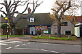
1
Superior Drive
Not a sign of snobbery, but part of a small development built in the 1990s with Canadian street names.
The development as a whole is known as "The Oaks", named after the Oak Brewery on whose site it was built. The brewery dominated the area for many years, having originally been founded in 1836. Fox's Ales were produced here, named after the owners of the brewery, the Fox family. However, it was forced to close in 1909, due to indebtedness, forcing over 100 people out of work, a considerable number for what was at the time a small village.
The buildings remained for a number of years, serving a variety of uses from time to time, before demolition in 1937. The site was then cleared and was developed in 1940 by the company Telegraph, Construction and Manufacture, later called Telcon, who moved here from Greenwich, manufacturing cables. Subsequently the site was occupied by Medway Packaging, before closure in 1992.
After various proposals, including a superstore, development of the site for housing was agreed, with this estate being built by Woolwich Homes.
Image: © Ian Capper
Taken: 13 Feb 2009
0.02 miles
2
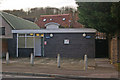
Public conveniences
Public conveniences on Green Street Green High Street, next to the Greenwood Centre.
Image: © Ian Capper
Taken: 27 Nov 2009
0.02 miles
3
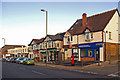
Green Street Green shops
Row of shops on Green Street Green High Street, including the former post office, now converted into a local police office. However, a report in the Bromley Times dated 21 October 2009 stated that despite conversion work having been completed in January 2009, the reception desk has remained unmanned ever since.
Image: © Ian Capper
Taken: 4 Dec 2009
0.03 miles
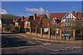
4
Lezayre Road, Green Street Green
Lezayre Road in Green Street Green, on the outskirts of London.
Image: © Malc McDonald
Taken: 31 Jul 2016
0.03 miles
5
The Greenwood Centre
Green Street Green's Community Centre, on the High Street, which opened in 1952.
The building was originally the coach house for Oak Brewery (see Image), being one of the only survivors from the large complex on the site.
Image: © Ian Capper
Taken: 27 Nov 2009
0.03 miles
6
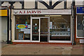
AJ Jarvis, Butchers
In "The Broadway" on the High Street in Green Street Green (see Image).
This shop has always been a butchers ever since the Broadway was built in 1912. Its original occupant was an Albert Greere.
Image: © Ian Capper
Taken: 27 Nov 2009
0.04 miles
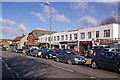
7
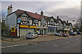
"The Broadway", High Street
The southernmost row of shops along the High Street in Green Street Green. This parade was built in 1912. The nearest premises was originally "A Crafter -Draper and Clothier, Boots and Shoes", run by an Arthur Crafter, a member of a local family, another member of whom had built the nearby Laxey and Lezayre Roads (the latter being the road seen on the left of this photo). More recently it has been an off-licence in the "Threshers" chain.
For more info on the next shop along, see Image
Image: © Ian Capper
Taken: 27 Nov 2009
0.04 miles
9
High Street
One of a number of parades of small shops in High Street.
Image: © Ian Capper
Taken: 13 Feb 2009
0.05 miles
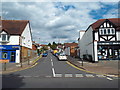
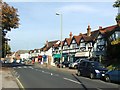
10
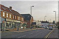
Green Street Green shops
As far as shops are concerned, Green Street Green High Street is very one sided - they line the eastern side of it for around 300 metres. This parade is in the middle of this stretch.
Image: © Ian Capper
Taken: 1 Dec 2009
0.05 miles