IMAGES TAKEN NEAR TO
Raleigh Mews, ORPINGTON, BR6 6NR
Introduction
This page details the photographs taken nearby to Raleigh Mews, BR6 6NR by members of the Geograph project.
The Geograph project started in 2005 with the aim of publishing, organising and preserving representative images for every square kilometre of Great Britain, Ireland and the Isle of Man.

There are currently over 7.5m images from over14,400 individuals and you can help contribute to the project by visiting https://www.geograph.org.uk
Image Map
Images are licensed for reuse under creativecommons.org/licenses/by-sa/2.0
Notes
- Clicking on the map will re-center to the selected point.
- The higher the marker number, the further away the image location is from the centre of the postcode.
Image Listing (54 Images Found)
Images are licensed for reuse under creativecommons.org/licenses/by-sa/2.0
Image
Details
Distance
5
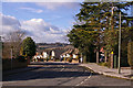
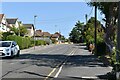
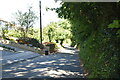
Glentrammon Road
Looking down towards Green Street Green, with the countryside south of Farnborough beyond.
Image: © Ian Capper
Taken: 13 Feb 2009
0.15 miles
6
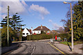
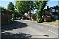
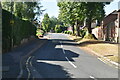
Glentrammon Road
Looking towards the junction with Highfield Avenue (on the right).
Image: © Ian Capper
Taken: 13 Feb 2009
0.15 miles