IMAGES TAKEN NEAR TO
Osgood Gardens, ORPINGTON, BR6 6JU
Introduction
This page details the photographs taken nearby to Osgood Gardens, BR6 6JU by members of the Geograph project.
The Geograph project started in 2005 with the aim of publishing, organising and preserving representative images for every square kilometre of Great Britain, Ireland and the Isle of Man.

There are currently over 7.5m images from over14,400 individuals and you can help contribute to the project by visiting https://www.geograph.org.uk
Image Map
Images are licensed for reuse under creativecommons.org/licenses/by-sa/2.0
Notes
- Clicking on the map will re-center to the selected point.
- The higher the marker number, the further away the image location is from the centre of the postcode.
Image Listing (52 Images Found)
Images are licensed for reuse under creativecommons.org/licenses/by-sa/2.0
Image
Details
Distance
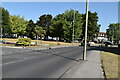
5
Cottage, Sevenoaks Road
This small cottage, Lime Tree Cottage, sits incongruously on the Green south of the junction of Warren Road with Sevenoaks Road. It was built here following the lease in 1814 of this patch of land to an Edward Bassett by the Lord of the Manor of Chelsfield, even though it was common ground, and the Lord of the Manor had no authority to do so. Despite this, no action was taken, and the cottage has remained.
Image: © Ian Capper
Taken: 13 Feb 2009
0.13 miles
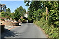
6
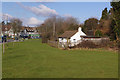
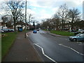
Bungalow at Green Street Green
Confusingly there are two Green Street Greens in this area, one between Dartford and Longfield, and this one to the south of Orpington. This open space alongside Sevenoaks Road (A223) is called The Green. This view is looking from The Green across Sevenoaks Road to a cottage which is a well-known landmark along this stretch.
Image: © Marathon
Taken: 30 Oct 2012
0.14 miles
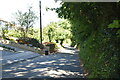
9
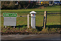
Coal Tax Post no 195
This Coal Tax Post (no 195 on the list linked to below) stands at the junction of Shire Lane and Sevenoaks Road. See Image for context. Grade II listed - for listing particulars see www.historicengland.org.uk/listing/the-list/list-entry/1186818.
Image: © Ian Capper
Taken: 13 Feb 2009
0.15 miles