IMAGES TAKEN NEAR TO
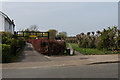
Wendover Way, ORPINGTON, BR6 0US
Introduction
This page details the photographs taken nearby to Wendover Way, BR6 0US by members of the Geograph project.
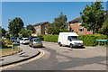
The Geograph project started in 2005 with the aim of publishing, organising and preserving representative images for every square kilometre of Great Britain, Ireland and the Isle of Man.

There are currently over 7.5m images from over14,400 individuals and you can help contribute to the project by visiting https://www.geograph.org.uk
Image Map
Images are licensed for reuse under creativecommons.org/licenses/by-sa/2.0
Notes
- Clicking on the map will re-center to the selected point.
- The higher the marker number, the further away the image location is from the centre of the postcode.
Image Listing (131 Images Found)
Images are licensed for reuse under creativecommons.org/licenses/by-sa/2.0
Image
Details
Distance
1
Entrance to Poverest Recreation Ground
Entrance to Poverest Recreation Ground off Footbury Hill Road.
Image: © Ian Capper
Taken: 24 Apr 2015
0.03 miles
2
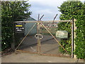
Poverest Allotments
These allotments are in a corner of Poverest Recreation Ground.
Image: © Ian Capper
Taken: 29 Jan 2008
0.03 miles
3
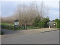
Entrance to Poverest Recreation Ground from Footbury Hill Road
On the left is the driveway for cars to a small carpark. On the right is the gate for Poverest Allotments.
Image: © Ian Capper
Taken: 29 Jan 2008
0.03 miles
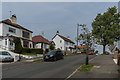
4
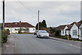
Perry Hall Close
1950s cul de sac off Perry Hall Road.
Image: © Ian Capper
Taken: 28 Mar 2013
0.04 miles
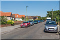
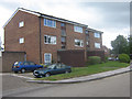
5
Glendower Crescent
1970s/80s mixed development off Goodmead Road.
Image: © Ian Capper
Taken: 17 Aug 2016
0.06 miles
6
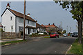
Footbury Hill Road
1930s housing in Footbury Hill Road. On the left is Footbury House.
Image: © Ian Capper
Taken: 24 Apr 2015
0.06 miles
7
Footbury Hill Road
1930s housing in Footbury Hill Road. In the background is Footbury House.
Image: © Ian Capper
Taken: 24 Apr 2015
0.06 miles
8
Goodmead Road
1950s(?) extension of Goodmead Road, which originally stopped at Perry Hall Road, with this section being a footpath.
Image: © Ian Capper
Taken: 17 Aug 2016
0.07 miles
9
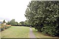
Poverest Park
Taken from the eastern entrance to the park at the end of Footbury Hill Road.
Image: © Trevor Harris
Taken: 11 Jul 2009
0.07 miles
10
Glendower Crescent
1970s/80s mixed development near Poverest Park.
Image: © Ian Capper
Taken: 25 Jun 2008
0.09 miles