IMAGES TAKEN NEAR TO
Bicknor Road, ORPINGTON, BR6 0TS
Introduction
This page details the photographs taken nearby to Bicknor Road, BR6 0TS by members of the Geograph project.
The Geograph project started in 2005 with the aim of publishing, organising and preserving representative images for every square kilometre of Great Britain, Ireland and the Isle of Man.

There are currently over 7.5m images from over14,400 individuals and you can help contribute to the project by visiting https://www.geograph.org.uk
Image Map
Images are licensed for reuse under creativecommons.org/licenses/by-sa/2.0
Notes
- Clicking on the map will re-center to the selected point.
- The higher the marker number, the further away the image location is from the centre of the postcode.
Image Listing (71 Images Found)
Images are licensed for reuse under creativecommons.org/licenses/by-sa/2.0
Image
Details
Distance
1
Housing diversity (Melbourne Close)
A series of photos showing the diversity of housing in one gridsquare in outer suburbia. For others in series see http://www.geograph.org.uk/search.php?i=1905481. Any further information, such as building dates and what was on the sites before building, would be appreciated.
This is Melbourne Close, a short interwar cul-de-sac off Lynwood Grove.
Image: © Ian Capper
Taken: 5 Jun 2008
0.03 miles
2
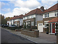
Housing diversity (Bicknor Road)
A series of photos showing the diversity of housing in one gridsquare in outer suburbia. For others in series see http://www.geograph.org.uk/search.php?i=1905481. Any further information, such as building dates and what was on the sites before building, would be appreciated.
This is Bicknor Road, a small 1970s (?) high density estate, in an area shown as recently as the 1940 1 inch map at http://www.npemap.org.uk/tiles/map.html#546,166,1 as an orchard, and in the 1970 1 inch map as an open space.
Image: © Ian Capper
Taken: 15 Nov 2007
0.04 miles
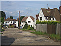
3
Bicknor Road
Part of the Sandycroft Estate built around 1970 between Crofton Lane and Chislehurst Road on the site of a former orchard of the same name.
Image: © Ian Capper
Taken: 19 Mar 2013
0.04 miles
4
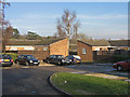
Housing diversity (Horsmonden Close)
A series of photos showing the diversity of housing in one gridsquare in outer suburbia. For others in series see http://www.geograph.org.uk/search.php?i=1905481. Any further information, such as building dates and what was on the sites before building, would be appreciated.
These single storey old person's flats are in Horsmonden Close, in part of the 1970s (?) development near the junction of Crofton Lane with Chislehurst Road. They are operated by Broomleigh Housing Association,
Image: © Ian Capper
Taken: 8 Jan 2009
0.05 miles
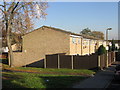
5
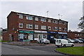
Fordwich Close
A row of local shops in Fordwich Close on the Sandycroft Estate, an estate built around 1970 between Crofton Lane and Chislehurst Road on the site of a former orchard of the same name.
Image: © Ian Capper
Taken: 19 Mar 2013
0.05 miles
6

Brookside
a short close built in the 1960s(?) off Mayfield Avenue.
Image: © Ian Capper
Taken: 22 Mar 2012
0.05 miles
7
Housing diversity (Brookside)
A series of photos showing the diversity of housing in one gridsquare in outer suburbia. For others in series see http://www.geograph.org.uk/search.php?i=1905481. Any further information, such as building dates and what was on the sites before building, would be appreciated.
Brookside, a short close built in the 1960s(?) off Mayfield Avenue.
Image: © Ian Capper
Taken: 23 Nov 2007
0.08 miles
8
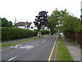
Lynwood Grove, Petts Wood
Like most of the roads in Petts Wood, Lynwood Grove is tree-lined. It is seen here from Crofton Lane.
Image: © Marathon
Taken: 9 Aug 2011
0.08 miles
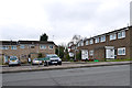
9
Housing diversity (Aylsham Road)
A series of photos showing the diversity of housing in one gridsquare in outer suburbia. For others in series see http://www.geograph.org.uk/search.php?i=1905481. Any further information, such as building dates and what was on the sites before building, would be appreciated.
Aylsham Road is part of the 1970s (?) development near the junction of Crofton Lane with Chislehurst Road.
Image: © Ian Capper
Taken: 2 Oct 2008
0.09 miles
10
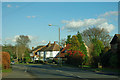
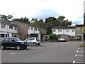
Houses on Crofton Lane
The turning for Lynwood Grove is directly ahead.
Image: © Robin Webster
Taken: 27 Jan 2012
0.10 miles