IMAGES TAKEN NEAR TO
The Walnuts, ORPINGTON, BR6 0TE
Introduction
This page details the photographs taken nearby to The Walnuts, BR6 0TE by members of the Geograph project.
The Geograph project started in 2005 with the aim of publishing, organising and preserving representative images for every square kilometre of Great Britain, Ireland and the Isle of Man.

There are currently over 7.5m images from over14,400 individuals and you can help contribute to the project by visiting https://www.geograph.org.uk
Image Map (Loading...)


Getting Data...Please wait
Leaflet Map data © OpenStreetMap
Images are licensed for reuse under creativecommons.org/licenses/by-sa/2.0
Notes
- Clicking on the map will re-center to the selected point.
- The higher the marker number, the further away the image location is from the centre of the postcode.
Image Listing (452 Images Found)
Images are licensed for reuse under creativecommons.org/licenses/by-sa/2.0
Image
Details
Distance
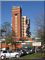
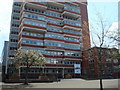
1
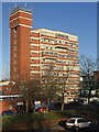
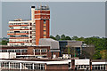
Orpington College
This college of further education, dating from 1972, is the tallest (and ugliest?) building in Orpington.
Image: © Ian Capper
Taken: 9 Nov 2007
0.00 miles
2
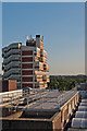
Walnuts rooftops
The roof of the Walnuts Leisure Centre with the tower of the Orpington Campus of Bromley College (formerly Orpington College) behind. Viewed from the Walnuts carpark.
Image: © Ian Capper
Taken: 5 Sep 2012
0.01 miles
3
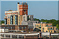
Orpington College - old and new
On the left is the original 1970s tower, on the right part of the new building opened in 2010.
Image: © Ian Capper
Taken: 23 Mar 2010
0.01 miles
4
Orpington College
Another picture (see Image]), this one showing more clearly the unusual (and ugly?) design.
Image: © Ian Capper
Taken: 9 Nov 2007
0.01 miles
6
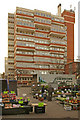
Orpington College and Market
The 1970s tower of Orpington College serves as a background to market stalls of the thrice weekly Orpington Market.
Image: © Ian Capper
Taken: 23 Mar 2010
0.01 miles
7
BR6
Restaurant operated by students in the Hospitality, Food and Enterprise Career College of Bromley College, situated on the College's Orpington Campus. On the right is part of the former Orpington Police Station, since demolished.
Image: © Ian Capper
Taken: 29 Jul 2015
0.01 miles
8
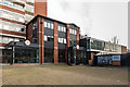
BR6
Restaurant operated by students in the Hospitality, Food and Enterprise Career College of Bromley College, situated on the College's Orpington Campus. The hoardings around the now demolished former Orpington Police Station on the right have been used to provide advertising space for the restaurant.
Image: © Ian Capper
Taken: 7 Dec 2015
0.01 miles
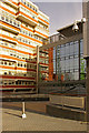
9
Orpington Campus
Formerly Orpington College, now the Orpington Campus of Bromley College. The main tower dates from 1972, with the building below it to its right dating from 2010. Viewed from the roof of the Memorial car park.
Image: © Ian Capper
Taken: 22 May 2012
0.01 miles
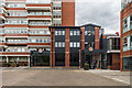
10
Orpington Campus and Brunswick Square
Looking from the Memorial Car Park across to the tower of what was originally Orpington College, and later through successive mergers the Orpington Campus of Bromley College and now the Orpington Campus of London South East Colleges. The main tower dates from 1972. Immediately in front of it is Brunswick Square, a development of 83 apartments built on the site of the former Orpington Police Station, completed in 2017-18.
Compare Image for the same view 6 years earlier.
Image: © Ian Capper
Taken: 17 May 2018
0.01 miles