IMAGES TAKEN NEAR TO
High Street, ORPINGTON, BR6 0NJ
Introduction
This page details the photographs taken nearby to High Street, BR6 0NJ by members of the Geograph project.
The Geograph project started in 2005 with the aim of publishing, organising and preserving representative images for every square kilometre of Great Britain, Ireland and the Isle of Man.

There are currently over 7.5m images from over14,400 individuals and you can help contribute to the project by visiting https://www.geograph.org.uk
Image Map
Images are licensed for reuse under creativecommons.org/licenses/by-sa/2.0
Notes
- Clicking on the map will re-center to the selected point.
- The higher the marker number, the further away the image location is from the centre of the postcode.
Image Listing (391 Images Found)
Images are licensed for reuse under creativecommons.org/licenses/by-sa/2.0
Image
Details
Distance
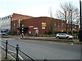
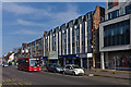
1
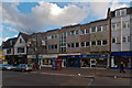
299-307 High Street
Much of the eastern side of High Street was redeveloped in the 1970s or so, and this is one of the blocks from this era.
Image: © Ian Capper
Taken: 22 Nov 2012
0.00 miles
2
299-307 High Street
Much of the eastern side of High Street was redeveloped in the 1970s or so, and this is one of the blocks from this era.
Image: © Ian Capper
Taken: 4 Mar 2013
0.01 miles
3
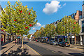
Orpington High Street - poppies
Poppy-bedecked trees in Orpington High Street, in preparation for Remembrance Sunday the following weekend.
Image: © Ian Capper
Taken: 6 Nov 2017
0.01 miles
4
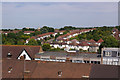
View from Memorial Car Park
Looking across the rooftops of the High Street, with the houses of Lancing Road behind.
Image: © Ian Capper
Taken: 24 Jun 2009
0.01 miles
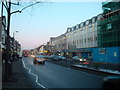
6
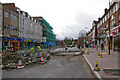
Orpington High Street improvement
Work underway the Orpington High Street Improvement scheme (see below).
Although initial work was on the pavements, late March/early April saw the southern end of the High Street closed to traffic for work on the roadway itself. The new paving can be seen on the right of this photo looking towards the War Memorial.
Image: © Ian Capper
Taken: 31 Mar 2010
0.01 miles
8
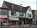
McDonald's
The Orpington McDonald's is housed on the site of the old cinema, demolished in 1985 - see http://www.ideal-homes.org.uk/bromley/assets/galleries/orpington/commodore-cinema.
Image: © Ian Capper
Taken: 23 Oct 2008
0.02 miles
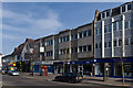
9
305-309 High Street
Much of the eastern side of High Street was redeveloped in the 1970s or so, and this is one of the blocks from this era.
Image: © Ian Capper
Taken: 4 Mar 2013
0.02 miles
10

Orpington High Street - poppies
A poppy-bedecked tree in Orpington High Street, in preparation for Remembrance Sunday the following weekend.
Image: © Ian Capper
Taken: 6 Nov 2017
0.02 miles