IMAGES TAKEN NEAR TO
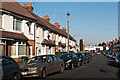
Watsons Yard, Perry Hall Road, ORPINGTON, BR6 0HL
Introduction
This page details the photographs taken nearby to Watsons Yard, Perry Hall Road, BR6 0HL by members of the Geograph project.
The Geograph project started in 2005 with the aim of publishing, organising and preserving representative images for every square kilometre of Great Britain, Ireland and the Isle of Man.

There are currently over 7.5m images from over14,400 individuals and you can help contribute to the project by visiting https://www.geograph.org.uk
Image Map (Loading...)


Getting Data...Please wait
Leaflet Map data © OpenStreetMap
Images are licensed for reuse under creativecommons.org/licenses/by-sa/2.0
Notes
- Clicking on the map will re-center to the selected point.
- The higher the marker number, the further away the image location is from the centre of the postcode.
Image Listing (274 Images Found)
Images are licensed for reuse under creativecommons.org/licenses/by-sa/2.0
Image
Details
Distance
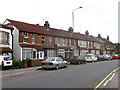
1
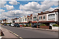
Perry Hall Road
Early 20th century development of the original part of Perry Hall Road, before it was extended westwards in the 1970s to become the main road to Chislehurst.
Image: © Ian Capper
Taken: 13 Jun 2012
0.03 miles
2
Perry Hall Road
Early 20th century development of the original part of Perry Hall Road, before it was extended westwards in the 1970s to become the main road to Chislehurst.
Image: © Ian Capper
Taken: 25 Jun 2008
0.03 miles
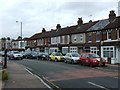
3
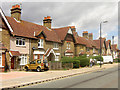
Elm Villas
A terrace of houses built in 1898 at the north end of the High Street. So called because of the elm trees that used to line the road here.
Image: © Ian Capper
Taken: 25 Jun 2008
0.04 miles
4
Perry Hall Road
Early 20th century development of the original part of Perry Hall Road, before it was extended westwards in the 1970s to become the main road to Chislehurst.
Image: © Ian Capper
Taken: 13 Jun 2012
0.04 miles
5
Perry Hall Road
Early 20th century development of the original part of Perry Hall Road, before it was extended westwards in the 1970s to become the main road to Chislehurst.
Image: © Ian Capper
Taken: 25 Jun 2008
0.04 miles
6
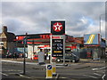
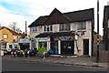
Petrol and tyres
The reason for including this very ordinary scene is that it is near the site of the garage built by Frank Smith and Jack Milroy in 1912. Here they created the Orpington Car, a two-seater convertible, with a dickey seat, and a 10 horsepower engine, first shown at the 1920 Motor Show. It won a number of awards, but was killed off by competition from mass production, with the last one being produced in 1925.
Image: © Ian Capper
Taken: 3 Dec 2007
0.04 miles
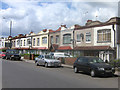
8
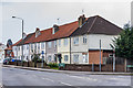
41 - 55 Perry Hall Road
Terrace of houses built in the 1910s or 1920s.
Image: © Ian Capper
Taken: 28 Mar 2013
0.05 miles
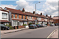
9
Elmcroft Road
The 1896 map shows a road here called Elmfield Road, with no houses and lined with trees. The 1909 map shows the road partially developed (and by now called Elmcroft Road). The houses seen here would seem to date from after World War I. In the background is Perry Hall Road.
Image: © Ian Capper
Taken: 3 Feb 2012
0.06 miles
10
7 - 9 High Street
A motor cycle business and a music shop in a former house at the north end of High Street.
Image: © Ian Capper
Taken: 16 Nov 2011
0.06 miles