IMAGES TAKEN NEAR TO
Oatfield Road, ORPINGTON, BR6 0ER
Introduction
This page details the photographs taken nearby to Oatfield Road, BR6 0ER by members of the Geograph project.
The Geograph project started in 2005 with the aim of publishing, organising and preserving representative images for every square kilometre of Great Britain, Ireland and the Isle of Man.

There are currently over 7.5m images from over14,400 individuals and you can help contribute to the project by visiting https://www.geograph.org.uk
Image Map (Loading...)


Getting Data...Please wait
Leaflet Map data © OpenStreetMap
Images are licensed for reuse under creativecommons.org/licenses/by-sa/2.0
Notes
- Clicking on the map will re-center to the selected point.
- The higher the marker number, the further away the image location is from the centre of the postcode.
Image Listing (339 Images Found)
Images are licensed for reuse under creativecommons.org/licenses/by-sa/2.0
Image
Details
Distance
1
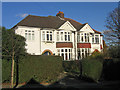
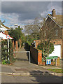
Housing diversity (Oatfield Road)
A series of photos showing the diversity of housing in one gridsquare in outer suburbia. For others in series see http://www.geograph.org.uk/search.php?i=1905481. Any further information, such as building dates and what was on the sites before building, would be appreciated.
An imposing semidetached house in Oatfield Road, part of the early 20th Century development of the Knoll area.
Image: © Ian Capper
Taken: 21 Nov 2007
0.01 miles
2

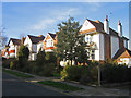
Oatfield Road
This cul-de-sac was built in around 1910 on land which was formerly part of the estate of Mayfield Place, on High Street.
In the background is the tower of Orpington College.
Image: © Ian Capper
Taken: 15 Mar 2012
0.01 miles
3
Housing diversity (Oatfield Road)
A series of photos showing the diversity of housing in one gridsquare in outer suburbia. For others in series see http://www.geograph.org.uk/search.php?i=1905481. Any further information, such as building dates and what was on the sites before building, would be appreciated.
A line of houses in Oatfield Road, part of the early 20th Century development of the Knoll area.
Image: © Ian Capper
Taken: 21 Nov 2007
0.01 miles
4
Oatfield Road
This cul-de-sac was built in around 1910 on land which was formerly part of the estate of Mayfield Place, on High Street.
In the background can be seen the tower of Orpington College (see Image).
Image: © Ian Capper
Taken: 12 Nov 2009
0.03 miles
5

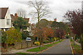
Oatfield Road
This cul-de-sac was built in around 1910 on land which was formerly part of the estate of Mayfield Place, on High Street.
The footpath on the right leads through to Stanley Road and is one of a network of paths that pre-existed the development of the area, when this was an area of strawberry fields.
Image: © Ian Capper
Taken: 15 Mar 2012
0.05 miles
6
Path from Knoll Rise to Orpington Station
Image: © David Howard
Taken: 29 Dec 2013
0.06 miles
7
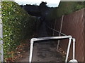
Footpath
One of a network of footpaths in the Knoll area of Orpington, the routes of which are shown on the 1868 Godfrey edition map of Orpington, which explains why they cut across the current, much more recent, road layout. This one leads from the junction of Oatfield Road with Lucerne Road to the junction of Keswick Road and St Kilda Road/Stanley Road, and is essentially an extension of the path shown in Image and Image
Image: © Ian Capper
Taken: 5 Mar 2009
0.06 miles
8
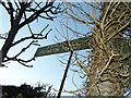
Sign to Orpington Station on Knoll Rise
These are not really attached to a tree, it's a sewer vent (stink pipe) with many years of branches growing up it.
Image: © David Howard
Taken: 29 Dec 2013
0.06 miles
9
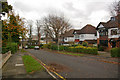
Lucerne Road
Lucerne Road was laid out around 1910, as part of the development of the Knoll area, although some houses are clearly more recent.
Image: © Ian Capper
Taken: 15 Mar 2012
0.07 miles
10
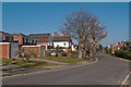
Stanley Road
This cul-de-sac was built in around 1910 on land which was formerly part of the estate of Mayfield Place, on High Street. The line of lime trees at the foot of the close was planted by Mary Vinson, the owner of Mayfield Place, to mark the new boundary.
In the background can be seen the tower of Orpington College (see Image).
Image: © Ian Capper
Taken: 12 Nov 2009
0.07 miles