IMAGES TAKEN NEAR TO
Lynwood Grove, ORPINGTON, BR6 0BD
Introduction
This page details the photographs taken nearby to Lynwood Grove, BR6 0BD by members of the Geograph project.
The Geograph project started in 2005 with the aim of publishing, organising and preserving representative images for every square kilometre of Great Britain, Ireland and the Isle of Man.

There are currently over 7.5m images from over14,400 individuals and you can help contribute to the project by visiting https://www.geograph.org.uk
Image Map
Images are licensed for reuse under creativecommons.org/licenses/by-sa/2.0
Notes
- Clicking on the map will re-center to the selected point.
- The higher the marker number, the further away the image location is from the centre of the postcode.
Image Listing (170 Images Found)
Images are licensed for reuse under creativecommons.org/licenses/by-sa/2.0
Image
Details
Distance
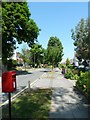
1

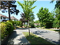
Lynwood Grove
A tree lined interwar development with large detached houses, each of a different design, built on the site of what in the early part of the 20th Century was a golf course.
Image: © Ian Capper
Taken: 22 Mar 2012
0.03 miles
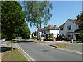
2
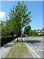
Looking towards a traffic island in Lynwood Avenue
Image: © Basher Eyre
Taken: 4 Jun 2010
0.03 miles
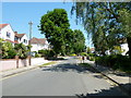
3
Housing diversity (Dale Wood Road)
A series of photos showing the diversity of housing in one gridsquare in outer suburbia. For others in series see http://www.geograph.org.uk/search.php?i=1905481. Any further information, such as building dates and what was on the sites before building, would be appreciated.
This is an extension to Dale Wood Road, with a group of modern houses in what the 1970 1 inch map shows as an open space above the railway.
Image: © Ian Capper
Taken: 15 Nov 2007
0.05 miles
8
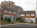
Housing diversity (Dale Wood Road)
A series of photos showing the diversity of housing in one gridsquare in outer suburbia. For others in series see http://www.geograph.org.uk/search.php?i=1905481. Any further information, such as building dates and what was on the sites before building, would be appreciated.
This is the latest (and presumably last) extension to Dale Wood Road (see Image and Image for other parts of the road), with a group of modern “executive” houses.
Image: © Ian Capper
Taken: 28 Nov 2007
0.08 miles
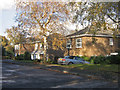
9
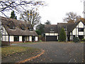
Housing diversity (Bancroft Gardens)
A series of photos showing the diversity of housing in one gridsquare in outer suburbia. For others in series see http://www.geograph.org.uk/search.php?i=1905481. Any further information, such as building dates and what was on the sites before building, would be appreciated.
These houses are in Bancroft Gardens, a development off Lynwood Grove on the site of St Nicholas’s School, an independent mixed school for 4 – 8 year olds, which was based in what had been the Club House of the Orpington Golf Club. It was finally demolished in 1969.
Image: © Ian Capper
Taken: 28 Nov 2007
0.08 miles
10
Knoll Lawn Tennis Club
Occupying an area of land between the back gardens of Lynwood Grove and Mayfield Avenue.
Image: © Ian Capper
Taken: 1 May 2009
0.08 miles