IMAGES TAKEN NEAR TO
Ramsden Road, ORPINGTON, BR5 4LT
Introduction
This page details the photographs taken nearby to Ramsden Road, BR5 4LT by members of the Geograph project.
The Geograph project started in 2005 with the aim of publishing, organising and preserving representative images for every square kilometre of Great Britain, Ireland and the Isle of Man.

There are currently over 7.5m images from over14,400 individuals and you can help contribute to the project by visiting https://www.geograph.org.uk
Image Map
Images are licensed for reuse under creativecommons.org/licenses/by-sa/2.0
Notes
- Clicking on the map will re-center to the selected point.
- The higher the marker number, the further away the image location is from the centre of the postcode.
Image Listing (40 Images Found)
Images are licensed for reuse under creativecommons.org/licenses/by-sa/2.0
Image
Details
Distance
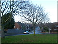
1
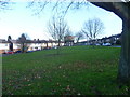
Looking across a green on the Ramsden Estate
This view is looking across a small green on the Ramsden Estate. Ramsden Road is on both sides of it.
Image: © Marathon
Taken: 16 Dec 2012
0.02 miles
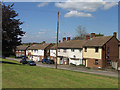
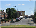
2
Ramsden Road
Late 1950s housing (1956 on the left, 1958 on the right), with the 1968 Crundale Tower at its head (and the similarly dated Hollingbourne Tower just visible beyond to its right).
Image: © Ian Capper
Taken: 29 Apr 2009
0.02 miles
3
Ramsden Road
A section of this late 1950s development separated from the main part of Ramsden Road by a small green.
Image: © Ian Capper
Taken: 29 Apr 2009
0.05 miles
5
Green on the Ramsden Estate
This view is looking across a small green next to Ramsden Road and down Dyke Drive.
Image: © Marathon
Taken: 16 Dec 2012
0.09 miles
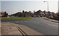
6
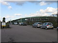
Bromley Indoor Bowls Centre
Opened in October 1997, partly funded with lottery money. See http://bromleyibc.com/index.php.
Image: © Ian Capper
Taken: 6 Feb 2008
0.10 miles
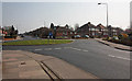
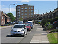
8
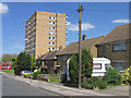
Ramsden Road
In the foreground is the roundabout where Ramsden Road is crossed by Kynaston Road/Gilmans Road. In the background is Crundale Tower with Hollingbourne Tower beyond, both built in the 1960s as part of the development of the Ramsden Estate.
Image: © Ian Capper
Taken: 29 Apr 2009
0.12 miles
9
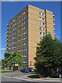
Crundale Tower
The first of three similar towers built in the late 1960s as part of the development of the Ramsden Estate, this one dating from 1967.
Image: © Ian Capper
Taken: 29 Apr 2009
0.13 miles
10
Tintagel Road
Part of the Ramsden Estate, with these houses built in 1958. Behind is the 1967 Crundale Tower (see Image).
Image: © Ian Capper
Taken: 29 Apr 2009
0.13 miles