IMAGES TAKEN NEAR TO
Bournewood Road, ORPINGTON, BR5 4JW
Introduction
This page details the photographs taken nearby to Bournewood Road, BR5 4JW by members of the Geograph project.
The Geograph project started in 2005 with the aim of publishing, organising and preserving representative images for every square kilometre of Great Britain, Ireland and the Isle of Man.

There are currently over 7.5m images from over14,400 individuals and you can help contribute to the project by visiting https://www.geograph.org.uk
Image Map
Images are licensed for reuse under creativecommons.org/licenses/by-sa/2.0
Notes
- Clicking on the map will re-center to the selected point.
- The higher the marker number, the further away the image location is from the centre of the postcode.
Image Listing (48 Images Found)
Images are licensed for reuse under creativecommons.org/licenses/by-sa/2.0
Image
Details
Distance
1
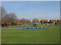
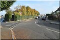
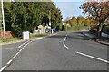
Playground, Grassmead Recreation Ground
Part of an open space north of the Ramsden Estate. The houses behind are in Stanton Close.
Image: © Ian Capper
Taken: 18 Mar 2009
0.10 miles
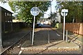
3
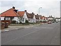
Northfield Avenue
1930s development along the route of an old footpath shown on earlier maps. Northfield itself is shown on the 1910 6" OS map as a large house to the south of this road, now all built on.
Image: © Ian Capper
Taken: 31 Mar 2009
0.12 miles
8
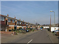
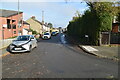
Finucane Drive
Part of the 1960s Grassmead Estate, built on the site of a large house here, Grassmead House, which in its later years housed St Philomena's Convent High School.
The roads in this estate are named after airmen who died in the Battle of Britain. For a biography of F/O B E F (Paddy) Finucane, see http://www.bbm.org.uk/as-finucane.htm. The road visible off to the right from this road is Beamish Drive, commemorating Wing Commander F V Beamish and in the background is Mungo Park Way, commemorating F/LT J C Mungo Park - see http://www.bbm.org.uk/as-mungopark.htm.
Image: © Ian Capper
Taken: 18 Mar 2009
0.16 miles