IMAGES TAKEN NEAR TO
Ronfearn Avenue, ORPINGTON, BR5 4BP
Introduction
This page details the photographs taken nearby to Ronfearn Avenue, BR5 4BP by members of the Geograph project.
The Geograph project started in 2005 with the aim of publishing, organising and preserving representative images for every square kilometre of Great Britain, Ireland and the Isle of Man.

There are currently over 7.5m images from over14,400 individuals and you can help contribute to the project by visiting https://www.geograph.org.uk
Image Map
Images are licensed for reuse under creativecommons.org/licenses/by-sa/2.0
Notes
- Clicking on the map will re-center to the selected point.
- The higher the marker number, the further away the image location is from the centre of the postcode.
Image Listing (29 Images Found)
Images are licensed for reuse under creativecommons.org/licenses/by-sa/2.0
Image
Details
Distance
1
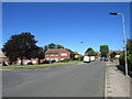
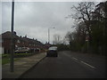
Burrfield Drive, St Mary Cray
Burrfield Drive is a residential road in St Mary Cray, in the outer suburbs of south east London.
Image: © Malc McDonald
Taken: 3 Oct 2021
0.09 miles
2
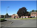
Berens Road, St Mary Cray
Berens Road is a residential road in St Mary Cray, in the outer suburbs of south east London.
Image: © Malc McDonald
Taken: 3 Oct 2021
0.10 miles
6
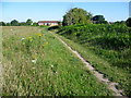
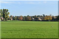
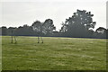
Footpath across Derry Downs
Derry Downs is an informal open space, just east of St Mary Cray. This view looks towards the houses of Hodson Crescent.
Image: © Marathon
Taken: 1 Jul 2011
0.12 miles
10
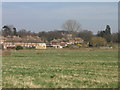
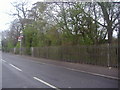
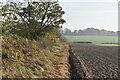
Derry Downs
The houses behind are in Burrfield Drive, and beyond is Kevington Hall, a Palladian villa completed in 1769 and commissioned by the owner of the estate, Herman Behrens, a City merchant from Amsterdam. It continued to be owned by the Behrens family until the Second World War, when it was requisitioned by the government to house Canadian troops. After the war it was used as a primary school until the early 1980s, when it became privately owned, with the new owners undertaking a full restoration. It is grade II* listed - for listing particulars see www.historicengland.org.uk/listing/the-list/list-entry/1359374. For closer view see Image
Image: © Ian Capper
Taken: 18 Mar 2009
0.14 miles