IMAGES TAKEN NEAR TO
Cherry Orchard Close, ORPINGTON, BR5 4BN
Introduction
This page details the photographs taken nearby to Cherry Orchard Close, BR5 4BN by members of the Geograph project.
The Geograph project started in 2005 with the aim of publishing, organising and preserving representative images for every square kilometre of Great Britain, Ireland and the Isle of Man.

There are currently over 7.5m images from over14,400 individuals and you can help contribute to the project by visiting https://www.geograph.org.uk
Image Map
Images are licensed for reuse under creativecommons.org/licenses/by-sa/2.0
Notes
- Clicking on the map will re-center to the selected point.
- The higher the marker number, the further away the image location is from the centre of the postcode.
Image Listing (88 Images Found)
Images are licensed for reuse under creativecommons.org/licenses/by-sa/2.0
Image
Details
Distance
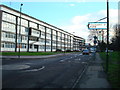
1
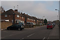
Elizabeth Way
1950s housing of High Street. Does the name suggest 1952 or 1953 as the actual building year?
Image: © Ian Capper
Taken: 16 Nov 2011
0.03 miles
2
Riverside Court
One of a number of similar housing blocks in St Mary Cray. In the background is another, Forgefield Court (see Image), with the since demolished Alkham Tower in the background.
Image: © Ian Capper
Taken: 16 Nov 2011
0.05 miles
3
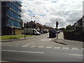
Junction of High Street and Elizabeth Way
High Street now has a 20mph speed limit, while the residential Elizabeth Way is 30mph.
Image: © Lindsey Coates
Taken: 25 Jun 2008
0.06 miles
4
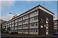
Forgefield Court
One of a number of similar housing blocks in St Mary Cray.
Image: © Ian Capper
Taken: 16 Nov 2011
0.07 miles
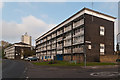
6
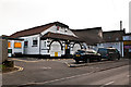
St Mary Cray Village Hall
Village hall on High Street. In 2007 the Village Hall Trust won the Bromley Council Group Environment Award for its restoration of hall, which had lain derelict for the previous 6 years.
Image: © Ian Capper
Taken: 16 Nov 2011
0.08 miles
7
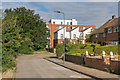
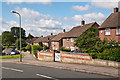
Okemore Gardens
The housing on the right was built in the 1950s. By contrast in the background is The Ridge, a development completed in 2014 on the site of the 1968 Alkham Tower (see Image for photo during its demolition). The nearer part of this development is Okemore Gardens Houses, with The Apex beyond.
Image: © Ian Capper
Taken: 29 Jul 2015
0.09 miles
8
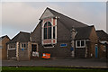
Moffat Hall
The church hall for the adjacent The Temple (see Image). Built in 1891, it was restored in 1950. The name commemorates the missionary Robert Moffat http://en.wikipedia.org/wiki/Robert_Moffat_(missionary) , father in law to David Livingstone. It is locally listed.
Image: © Ian Capper
Taken: 16 Nov 2011
0.09 miles
9
Burrfield Drive
1950s housing off Blacksmiths Lane.
Image: © Ian Capper
Taken: 19 Jul 2012
0.10 miles
10
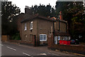
208 High Street
18th century grade II listed house - see www.historicengland.org.uk/listing/the-list/list-entry/1370053.
Image: © Ian Capper
Taken: 16 Nov 2011
0.10 miles